Region · Namibia
Kavango West
The quiet western half of the old Kavango Region, with villages along the Kavango River, the river town of Nkurenkuru as capital and the little-visited Mangetti National Park.
Short answer
This page covers 1 parks and reserves and 1 towns and cities in Kavango West.
- Parks and reserves
- 1
- Towns and cities
- 1
- Where
- Namibia18.31°S 18.91°E
Parks and reserves in Kavango West
1Towns and cities in Kavango West
1Written up in smaller places around Kavango West
2
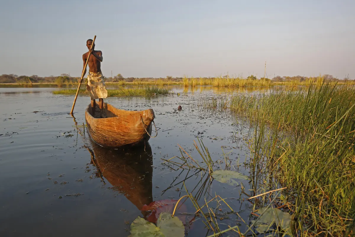
Kavango West is the western half of what used to be the Kavango Region, split off in 2013. Life here follows the Kavango River (Okavango), which is also the border with Angola. Most of the 123,266 people counted in the 2023 census live in villages along that river strip, and more than nine in ten live in rural areas. Inland it is Kalahari woodland with very few people. Visitors are rare, which is the attraction: this is river country that tour buses skip.
Getting there
Rundu, the big town of the Kavango, is about 250 km from Grootfontein on the tarred B8. From Rundu the B10 follows the Angolan border west to Nkurenkuru, the regional capital, a stretch The Namibian puts at 134 km. The B15 comes up from Tsumeb through Tsintsabis and Mpungu to the Katwitwi border post on the river, roughly 35 km north-west of Nkurenkuru. Off the B roads expect gravel and sand. Wikivoyage warns that the Kavango’s D roads are sandy and corrugated, and that rain makes them worse.
When to go
Going by the figures for nearby Rundu, rain falls mainly from November to March, with January the wettest month. October, just before the rains, is the hottest, with afternoons averaging about 35 °C. June and July bring warm days and chilly nights that average about 6 °C. Almost no rain falls from May to September, and since rain makes the D roads worse, those dry months are the easier time to drive them.
What to do
Mangetti National Park lies about 100 km south-west of Rundu. It covers 420 km² of old dunes and woodland on land the Uukwangali Traditional Authority first set aside for conservation, and part of its income goes to the communities around it. MEFT lists sable antelope, wild dog, leopard and hyaena among its animals. The bush is dense, so sitting at a waterhole beats driving around. The park is open to day visitors only, and the park fees are in the table on its page.
Nkurenkuru itself is the seat of the Uukwangali kings and sits on the river opposite Cuangar in Angola. The Catholic mission at Tondoro, about 15 km away, dates from 1927. Otherwise this is a place for slow drives past riverside villages and markets.
Good to know
- This is a malaria area. The US CDC recommends prescription tablets for both Kavango regions, so talk to a travel doctor before you go.
- Fill up in Rundu, which has several filling stations, before heading west.
- Take a 4x4 into Mangetti. Some of its tracks are very sandy.
- Mangetti lies north of the Mururani veterinary gate, and you cannot stay overnight in the park. The usual plan is to sleep at a lodge south of the fence and drive in. Kavango West is north of the fence, and taking animal products south across it is banned, so expect the officials at Mururani to look in your cool box on the way south and take any meat. Travellers on a 4x4 forum say the same.
- Places to stay are few and simple. Book ahead.
History and culture
Kavango West is the home country of the Vakwangali, the westernmost of the five Kavango kingdoms, whose kings (hompa) still have their homestead at Nkurenkuru on the river. Its story is one of a people split by a border that Portugal and Germany agreed in 1886, of German officials and Finnish and Catholic missionaries arriving late, and of a frontier that saw war across the river in Angola for decades. Knowing it turns a drive along the B10 into more than a string of villages.
- Mid 1700s
Hompa (queen) Mate I led the Kwangali about 500 km west from the Kwando River to the Kavango, settling near Makuzu, about 20 km north-west of present-day Nkurenkuru. Under her successor Nankali the people moved again along the river, as far as Karai near today's Cuangar. source
- 1820
Nkurenkuru was founded in 1820, probably under hompa Siremo, and by 1880, under King Mpande, it had become the homestead of the Kwangali kings. The name means the old place in Rukwangali. source
- 1886
On 30 December 1886 Portugal and Germany agreed to run the border between Angola and German South West Africa along the river. The Kavango kingdoms, which lived on both banks, were told only afterwards, and Portugal built Fort Cuangar right opposite the Kwangali royal homestead. source
- 1909 to 1914
German rule came late here. King Himarua signed a protection treaty with the German administrator Berengar von Zastrow on 17 August 1909, a German police post opened at Nkurenkuru in June 1910, and on 31 October 1914, after the killing of a German delegation at Naulila, German troops crossed the river and killed all 30 Portuguese and Angolan soldiers at Fort Cuangar. source
- 1921 to 1936
After the First World War the territory became a League of Nations mandate under South Africa, and from April 1921 a permanent governor ran the new Kavango district from Nkurenkuru. In 1936 the administration moved to Rundu, and Nkurenkuru slipped into the background for the next 50 years. source
- 1966 to 1990
The war of independence, fought by SWAPO's guerrillas against South African rule, began on 26 August 1966 and ended with independence on 21 March 1990. As early as May 1967 South Africa set up a post at Rundu, just east of this region, to coordinate air operations with the Portuguese army fighting in Angola. source
- 1970 to 1989
Under apartheid South Africa made the Kavango a bantustan, a so-called self-governing homeland for one ethnic group, set up in 1970 and given self-government in 1973 with its headquarters at Rundu. It was replaced in 1980 by an ethnic Representative Authority and abolished in May 1989 as the transition to independence began. source
- 2013
In August 2013 the Kavango Region was split in two on the advice of the Fourth Delimitation Commission. Nkurenkuru became the capital of the new Kavango West Region and is its only self-governed settlement. source
- Language
- Rukwangali is the main home language of 74.5 percent of households in the 2023 census, far ahead of anything else. Another 12 percent gave a Kavango language that was not named more closely, and Oshikwanyama, English, Rumanyo and Rumbunza follow with small shares. source
- Peoples
- The Vakwangali make up 60 percent of the population in the 2023 census, and another 22 percent were recorded simply as Kavango. The Vambunza, San, Nyemba, Aakwanyama, Vagciriku and Vasambyu follow with a few percent or less each. source
- Kingdoms and family
- The Kavango peoples are organised in five kingdoms (Kwangali, Mbunza, Shambyu, Gciriku and Mbukushu), each headed by a hompa or fumu, the words for king. Descent runs through the mother's line, and the ekoro, an extended family rooted in the clan rather than blood alone, ranks people by the seniority of their clan and sets who owes respect to whom. Traditional law is recognised by the Namibian constitution. source
- Food
- Pearl millet porridge is the staple, and millet is also brewed into a fermented drink. Kitchens are traditionally thatched huts built outside the house, and at harvest time in April the Vakwangali dig up a tuber they call mafumpura. source
- Churches
- Finnish Lutheran missionaries started their Kavango work at Nkurenkuru on New Year's Day 1929, when Eetu Järvinen arrived to put up the first mission building. In 1990 the Evangelical Lutheran Church in Namibia (ELCIN) opened a secondary school in the town with Finnish help. source
For German visitors: German rule over the Kwangali was formalised only in 1909, when Berengar von Zastrow signed a protection treaty (Schutzvertrag) with King Himarua. The German police post at Nkurenkuru (1910) was the base for the October 1914 attack on Portuguese Fort Cuangar across the river. source
For German visitors: The Benedictine sisters at Tondoro belong to the Missionary Benedictine Sisters of Tutzing in Germany. Their first eight sisters left Tutzing in November 1920 and boarded the Baltika in Hamburg, and the congregation soon opened stations in the Kavango, where its Tondoro community still works. source
Main sights in Kavango West
4- Nkurenkuru
The capital and seat of the Uukwangali kings, on the river directly opposite Cuangar in Angola, where the Portuguese fort stood that German troops attacked in 1914. Treat the royal homestead as a private home, not an attraction.
Wikipedia: Nkurenkuru - St Laurence Mission, Tondoro
A Catholic mission about 15 km south-east of Nkurenkuru, founded in 1927 by Father Weilhöfer of the Missionary Oblates of Mary Immaculate. In 2015 five Benedictine sisters ran a girls' hostel and a clinic there, and the mission served 35 communities along the river.
Wikipedia: Tondoro - Mpungu
An inland former Finnish mission station about 40 km south-west of Nkurenkuru, founded in 1951 by the nurse Hellin Elomaa, who also opened a small clinic. The missionaries here were also in touch with the local San.
Wikipedia: Mpungu - Mangetti National Park
A 420 km² park in the eastern Kalahari woodlands, on land first set aside for conservation by the Uukwangali Traditional Authority and meant to share its benefits with local communities. MEFT lists sable antelope, wild dog, leopard and hyaena, and the park is open to day visitors only.
Ministry of Environment, Forestry and Tourism: Mangetti National Park
Did you know?
- Only 8.5 percent of the 123,266 people counted in 2023 live in a town. The region averages 5 people per km², but Nkurenkuru constituency has 58.4 per km² while inland Ncamagoro has just 1.7. source
- Rukwangali is a Bantu language with click consonants, a sound it is thought to have picked up from neighbouring Khoisan languages. source
- Nkurenkuru was the seat of the Kavango district once before, until 1936. It was declared a town only in 2006, and when it became a regional capital again in 2013 it was the smallest town in Namibia. source
- During the Angolan Civil War (1975 to 2002) the South African Defence Force kept a base at Nkurenkuru. The Nepara airfield about 20 km south-west of town, a former South African Air Force base, now serves as its commercial airstrip. source
- Mangetti was fenced off as a game camp in 1973 and 1974. The Uukwangali Traditional Authority lobbied from 1992 for it to be protected, it was proclaimed a national park in September 2008, and it was formally opened on 10 October 2014. source
- Mangetti shares its name with the mangetti tree (Schinziophyton rautanenii), which grows there with silver terminalia and camel thorn. The park's main landform is lines of ancient dunes running north-west to south-east. source
Checked 7 October 2026.
In and around Kavango West
3 places listedBars and pubs 3
- Yotate Napinga ShebeenBar
- SIHOGWENA BARBar
- VILLAGE HOUSE BARBar
Guides for Kavango West
Map of Kavango West
See every place on this map as a list