Region · Namibia
Kavango East
The river region from Rundu into the western Caprivi Strip, with Angola across the Okavango, woodcarvers and old missions, Popa Falls, Mahango and the remote Khaudum park.
Short answer
This page covers 2 parks and reserves and 3 towns and cities in Kavango East. 2 of the parks have checked entry fees: international adults pay from N$200 at Khaudum National Park to N$200 at Popa Falls Game Park.
- Parks and reserves
- 2
- Towns and cities
- 3
- Places to stay
- 5
- Where
- Namibia18.49°S 20.38°E
Parks and reserves in Kavango East
2Towns and cities in Kavango East
3Written up in smaller places around Kavango East
1
Kavango East is the region along the Okavango River (called the Kavango in Namibia) from Rundu east into the western half of the Caprivi Strip, with Angola across the water and Botswana to the south and south-east. Rundu, the capital, holds more than half of the region’s 218,421 people (2023 census). Most travellers only see it from the B8, but the river is the reason to slow down: fishing villages, woodcarvers, old Catholic missions, Popa Falls, Mahango and the very remote Khaudum park.
Getting there
Almost everyone drives. The tarred B8 runs about 250 km from Grootfontein to Rundu, then follows the river east to Divundu and on into Bwabwata. Long-distance coaches between Windhoek and Zambia stop at Rundu and Divundu. For Botswana, the C48 leaves Divundu through Mahango to the Mohembo border post. Rundu also has a crossing over the river to Calai in Angola; ask locally before planning to take a car across.
When to go
The dry season runs from about April to November, and most of the year’s rain falls from December to March. June to October is best for game, when animals gather at the river and the waterholes. Birders do better from November to March. Winter nights can drop to 5 °C or lower, while summer days reach 30 to 40 °C and the air turns humid.
What to do
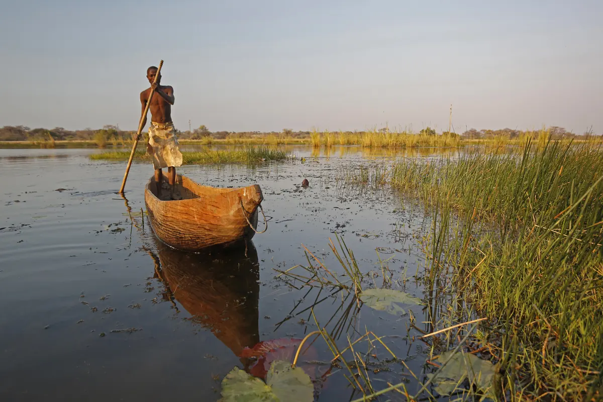
Rundu is a working town rather than a sight, but it is the place to buy carvings. Kavango men carve drums, masks, furniture and dugout canoes, and stalls line the B8 into town from Mile 30. Lodges on the river run boat trips, canoeing and fishing.
Further east are the old Catholic missions at Nyangana, the first in the Kavango, and Andara, about 200 km east of Rundu. Popa Falls, rapids in Namibia’s smallest game park, and the Mahango core area of Bwabwata, with its baobabs, sable and roan, are the easy wildlife stops.
Khaudum National Park, in the south-east, is the opposite of Etosha. Visitor numbers stay under 3,000 a year by the ministry’s count, the handful of tracks are deep Kalahari sand, and you are likelier to meet an elephant than another visitor. The northern gate is at the end of a 46 km sand track off the B8 between Rundu and Divundu.
Good to know
UK travel health advice puts the whole region at high risk of malaria all year, and the CDC recommends antimalarial tablets. See a travel clinic before you leave. For Khaudum the ministry asks for at least two 4x4 vehicles per party, three days of food per person and 100 litres of water per vehicle; there are no shops in or near the park. The nearest fuel is in Rundu (or Tsumkwe if you come in from the south), and deep sand roughly doubles what you burn. C roads are gravel an ordinary car can usually manage, but D roads are sandy and corrugated and worse after rain. North of the veterinary fence (the Red Line) cattle are not fenced in and often walk onto the road, so avoid driving after dark. Park fees are in the tables on the Khaudum, Popa Falls and Bwabwata pages.
History and culture
Kavango East is the home country of the Kavango kingdoms, river peoples who farm and fish the south bank of the Okavango. Its past is a frontier story: German rule that barely reached it, Catholic missions from 1909, an apartheid homeland governed from Rundu, an army zone during the liberation war, and a capital, Rundu, that has nearly doubled in size since 2011.
- 1785
The recorded list of Gciriku kings, one of the Kavango peoples, starts with Shimwemwe, who ruled from 1785 to 1805 and lived at Ndonga-linena and Mpupa. Each hompa (king) kept a royal homestead (mbara), and the list notes where each one stood. The line has a king today. source
- Around 1900
The Portuguese, who ruled Angola on the north bank, built forts along the river, and many Kavango who had lived on the Angolan side moved to the south bank. Germany had claimed the south bank, but the first German expedition into the Kavango, under Richard Volkmann, only came in June 1903. source
- 1909
On 21 May 1909 the German Catholic missionary Joseph Gotthardt founded the first mission in the Kavango at Nyangana, named after the Gciriku king Thomas Nyangana. A mission at Andara, among the Hambukushu, followed in 1913. source
- 1936
The South West African administration founded Rundu on a rise above the river as the seat of government for the Kavango, replacing Nkurenkuru, which was too hard to reach. Until the 1940s the town was also written Runtu. source
- 1966
After the International Court of Justice declined to rule on South African control of the territory, SWAPO began an armed struggle that grew into the wider regional conflict known as the South African Border War. source
- 1969 to 1975
Under apartheid Rundu was divided by race. Black residents were moved out of the Tutungeni neighbourhood and resettled in Nkarapamwe. source
- 1970 to 1989
South Africa set up Kavangoland, a homeland (Bantustan) for the Kavango people, with a legislative council in Rundu from 1970 and self-government from 1973. It was abolished in May 1989 at the start of the move to independence. source
- 1972 to 1990
A military base was built at Rundu in 1972 and enlarged in 1976, during South Africa's occupation of the territory. It is now a Namibian Defence Force base named after Voito Jason Kondjeleni, a fighter of SWAPO's armed wing PLAN who died in 1983. source
- 21 March 1990
Namibia became independent, and Sam Nujoma of SWAPO was sworn in as its first president. source
- 2013
In 2013, on the advice of the Fourth Delimitation Commission, the old Kavango Region was split in two: Kavango East with Rundu as its capital, and Kavango West with Nkurenkuru. source
- Languages
- In the 2023 census the main home languages in Kavango East households were Rukwangali (28.4%), Rumanyo, which covers Rugciriku and Rusambyu (25.7%), and Thimbukushu (15.1%). English was the main language in 3% of homes. source
- Peoples
- The largest groups counted in the 2023 census were the Vakwangali (20.6%), Vagciriku (19.3%) and Hambukushu (17.5%), then the Nyemba and people recorded simply as Kavango (11.5% each), with the Vasambyu at 4.9%. source
- Kingdoms and family
- The Kavango are divided into five kingdoms, Kwangali, Mbunza, Shambyu, Gciriku and Mbukushu, each led by a hompa or fumu (king), and their traditional law is recognised under the constitution. Descent runs through the mother's line, and the ekoro, the clan or extended family, still shapes who owes respect to whom. source
- Crafts
- Carving is men's work here. They use dolfwood, a tree of the Kalahari sandveld, and turn out everything from ceremonial drums and masks to chairs, tables and dugout canoes, and Kavango carvings turn up in curio shops across Namibia. Women make baskets and clay pots, which they sell to visitors. source
- Food
- Traditional dishes are on the menu at several Rundu restaurants: mahangu (pearl millet), groundnuts, stews and fish caught in the Okavango. source
For German visitors: The Nyangana mission hospital was founded in 1936 by German Benedictine sisters of Tutzing, and at the time it was the only hospital in the whole Kavango. source
For German visitors: The Caprivi Strip (Caprivizipfel), split today between this region and Zambezi, is named after the German chancellor Leo von Caprivi, who negotiated it from Britain in 1890. source
For German visitors: The veterinary fence called the Red Line, which still divides northern Namibia from the commercial farms of the centre and south, began as a German rinderpest line in 1896 and takes its name from the red ink on a German colonial map of 1911. source
For German visitors: The German government, through the development bank KfW, has paid for infrastructure, equipment and planning in Bwabwata National Park, which runs from the Okavango in the west to the Kwando in the east. source
For German visitors: Police officers from Germany were among the United Nations UNTAG contingent based in Rundu in 1989 and 1990, which oversaw the elections that led to independence. source
Main sights in Kavango East
6- Rundu markets and woodcarvers
The Rundu Open Markets east of the centre, and the carvers' stalls along the main road into town between Mile 30 and Mile 10, are where to see and buy the carving the Kavango are known for.
Wikivoyage, Rundu - Nyangana mission
The first Catholic mission in the Kavango, founded in 1909 on the south bank of the river. It is now linked to the Kavango Community Development Foundation, with support from Kayova River Lodge, and runs community projects such as nurseries, kindergartens and clean water for villages.
Namibia Tourism Board, Kavango Open Africa Route - Andara mission
The Holy Family Parish at Andara, about 200 km east of Rundu, set up in 1913 among the Hambukushu. Its hospital, built in the 1960s, still runs, so visit with respect.
Namibia Tourism Board, Kavango Open Africa Route - St Mary's Cathedral, Rundu
The seat of the Catholic Apostolic Vicariate of Rundu, a reminder of how deep the missions' roots go in this region.
Wikipedia, Rundu - Popa Falls
Four-metre rapids where a quartzite ledge crosses the Okavango, inside a tiny park of riverine forest with a rest camp, a restaurant and walks.
Ministry of Environment, Forestry and Tourism, Popa Falls Game Park - Khaudum National Park
Remote Kalahari woodland with fossil river beds (omurambas), artificial waterholes and hides, and a refuge for wild dog and roan. Go only with two 4x4 vehicles and full supplies.
Ministry of Environment, Forestry and Tourism, Khaudum National Park
Did you know?
- Rundu Urban counted 118,632 people in the 2023 census, more than half of the region's 218,421, and the region grew by 59.6% between 2011 and 2023. source
- Khaudum National Park covers 3,842 square kilometres and gets fewer than 3,000 visitors a year. It is unfenced except along the Botswana border, so elephants and other game move freely to the farms and conservancies around it. source
- Mashare, just east of Rundu, had a leprosy hospital that treated thousands of patients from Namibia, Angola and Botswana until the war closed it in the early 1980s. In 2011 it was still home to the largest community of people with leprosy in Namibia. source
- The Okavango begins in Angola, where it is called the Cubango, runs south-east for about 1,600 km and ends in Botswana without ever reaching the sea. source
- Popa Falls Game Park is Namibia's smallest game park, yet 417 bird species have been recorded there. source
Checked 7 October 2026.
In and around Kavango East
7 places listedWhere to stay in Kavango East 5
- 18.02°S 20.75°EHotelKayova River LodgeP.O. Box 2432, Rundu+264 66 686 051
- 18.01°S 20.70°EGuest houseMoyos Guesthouse+264 66 258 824
- 17.87°S 20.28°ECampsiteMukuku Restcamp
- 18.29°S 20.70°ECampsiteRupara Camp
- 17.96°S 20.51°EGuest houseShankara Rest Camp
Bars and pubs 2
- LikoraBar
- SitokwesaBar
Guides for Kavango East
Map of Kavango East
See every place on this map as a list