Camdeboo National Park
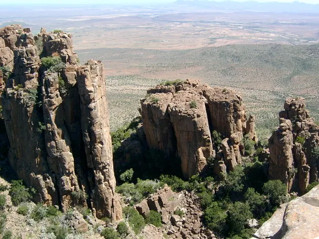
Dolerite columns of the Valley of Desolation, plains game and a dam, wrapped around the Karoo town of Graaff-Reinet. Best at the golden hour.

What you'll pay to enter Camdeboo National Park
VALID 01 NOV 2025 TO 31 OCT 2026 · ZAR PER PERSON PER DAY
| Fee | SA residents |
|---|---|
| Daily conservation fee | R52child R26one source |
- Only the South African citizen and resident rate is shown; no source we could open gave the SADC or international rate for this period.
- Wild Card members do not pay daily conservation fees.
- Child rate applies to ages 2 to 11; children under 2 enter free.
- Figures marked "one source" were found in a single published source only.
- Set by South African National Parks (SANParks). Adult rate shown first, child rate below. Official tariff
CHECKED 06 OCT 2026 · 1 SOURCES
See every place on this map as a list
Camdeboo National Park almost completely surrounds Graaff-Reinet, the fourth-oldest town in South Africa, which means you can eat breakfast under a Cape Dutch gable and be looking down 120 m dolerite columns twenty minutes later. The name comes from a Khoi word meaning green valley, which is optimistic. This is Karoo: 194 square kilometres of dry plains, the Nqweba Dam and the foothills of the Sneeuberg, rising from 740 m to 1,480 m. It became the country’s 22nd national park in 2005 after years as a provincial nature reserve.
Getting there
Graaff-Reinet is about 250 km from Gqeberha (Port Elizabeth) and roughly 600 km, or seven hours, from Cape Town. The park has two entrances. The one most people want, for the Valley of Desolation and the game-viewing area, is 5 km out of town on the R63 towards Murraysburg. The second is on the N9 towards Richmond, 4 km from town. Gate hours shift with the season, opening earlier and closing later in summer; the valley road closes after sunset, so check current times at reception on the day.
When to go
Summers are hot with afternoon thunderstorms. Winter days are sunny and mild but the nights are bitterly cold. Spring brings a scatter of wildflowers. Whatever the month, go up to the Valley of Desolation early in the morning or in the last hour before sunset, when the light hits the columns side-on and the plains of the Camdeboo turn gold.
What to do
A tarred road climbs to the Valley of Desolation with viewpoints along the way, so any car manages it. The columns are dolerite that cooled slowly underground around 180 million years ago and was exposed as softer rock eroded. From the top, the Crag Lizard Trail (1.5 km, 30 to 45 minutes) follows the rim, marked by lizard symbols, with interpretive boards and alpine swifts shooting past at head height.
The game-viewing area beside the Nqweba Dam holds Cape mountain zebra, kudu, red hartebeest, black wildebeest, blesbok, springbok, bat-eared fox and meerkat, with buffalo occasionally in view. The park records 43 mammal species, more than 220 birds and 336 plant varieties. Longer walks include the Eerstefontein Day Walk (5 to 16 km over three route options) and the Gideon Scheepers Trail. For 4x4 owners there are the Koedoeskloof drive (three hours or more, a proper 4x4 needed) and the gentler Driekoppe drive in the eastern section, for which you collect a gate key at reception.
Good to know
- No shops, fuel or ATMs in the park. Graaff-Reinet has all of them a few minutes away.
- In-park accommodation is the Lakeview Tented Camp (four furnished tents, communal kitchen) and the Nqweba Campsite with 15 powered stands. Both are small; book ahead.
- Do not hike alone, tell someone when you expect to be back, and watch for snakes on hot days. The rim has real drops; keep children close.
In and around Camdeboo National Park
17 PLACESPlaces to stay 4

- 32.21°S 24.54°ECampsiteLakeview Tented CampRobert Sobukwe Town
- 32.29°S 24.65°ECampsiteDriekoppe Hiking Huts
- 32.29°S 24.65°ECampsiteWaaihoek Rustic 4x4 Campsite
Sights 13
 Valley of DesolationViewpoint
- Andies PretoriusMonument
- Ascon Site officeViewpoint
- Dam wallViewpoint
- Driekoppe WaterholeAttraction
- Gideon Scheepers MonumentMemorial
- Khwalimanzi HideAttraction
- Kleinhoek WaterholeAttraction
- Koedoeskloof WaterholeAttraction
- Kwaggakom WaterholeAttraction
- Ribbokberg LookoutViewpoint
- ToposcopeViewpoint