City · Oshana, Namibia
Oshakati
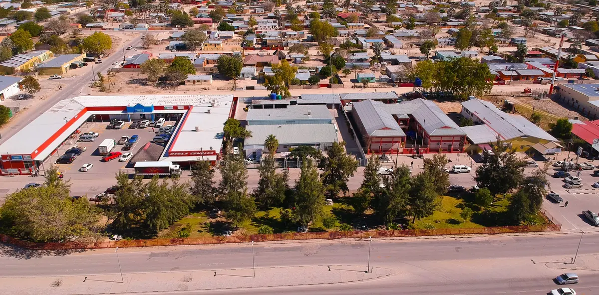
Capital of the Oshana Region and the commercial centre of Namibia's populous north, a busy working town with a big open market and few tourists.
Short answer
Oshakati is in Oshana, Namibia. This page lists 8 places to stay, 5 places to eat and drink and 1 sight. The nearest park with an entry fee on this site is Etosha National Park, about 134 km away, where international adults pay from N$280.
- Places to stay
- 8
- Eat and drink
- 5
- Sights
- 1
- Park fee nearby: Etosha National Park
- US$17 €15 · N$280about 134 km away
In and around Oshakati
14 places listedWhere to stay in Oshakati 8
- 17.79°S 15.71°EHotelRochas hotel & portugues restaurantMain Road, Oshakati+264 65 222 036rochashotel.com
- 17.77°S 15.69°EGuest houseKate's Nest GuesthouseOshakati+264 81 122 9151katesnest.com
 HotelOshakati Guest HotelKwame Nkrumah Road, Oshakati
- HostelOshakati Youth HostelSam Nujoma Road, Oshakati
- 17.79°S 15.71°EGuest houseCubita GuesthouseLeo Shopala Street, Oshakati
- 17.79°S 15.70°EHotelOshakati Country Lodge
- 17.79°S 15.71°EGuest houseOshakati Guest House
- 17.79°S 15.70°EHotelOshandira Lodge
Sights 1
- Dr Frans Aupa Indongo Open MarketAttraction
Restaurants and cafes 4
- SOS clubRestaurant · pizza
- Ekepi BarRestaurant
- Harare resting PubCafe
- M & M RestaurantRestaurant
Bars and pubs 1
- OmwandiBar
Oshakati is the capital of the Oshana Region and the shopping and business centre of Namibia’s crowded north, the Ovambo heartland. The 2023 census counted 58,656 people in town. It was founded in July 1966, under South African rule, and through the liberation war it was a base for the South African army. Most people who come are here for work or the market. Tourists are few.
Getting there
Most visitors drive. The C46 is tarred all the way from the B1 at Ondangwa, through Oshakati, then west via Oshikuku and Outapi to Ruacana, 188 km in all. Ondangwa has the nearest airport, with scheduled flights to Windhoek and Walvis Bay (it is now called Andimba Toivo ya Toivo Airport). Shared taxis are everywhere in town and also run to Ondangwa, and the big coaches between Windhoek and Lusaka stop at Oshakati and Ondangwa.
When to go
The rains come from about November to April and are heaviest from January to March. That matters here because the town sits on the flat Cuvelai floodplain and is cut by the Okatana River, so it floods in wet years (badly in 2008). October is the hottest month, with afternoons around 34 °C. June and July are dry and mild, but nights can drop to about 7 °C, so pack a warm layer.
What to do
Go to the Dr Frans Aupa Indongo Open Market, opened in March 2016 and run by the town council. It is the place to see the north as it shops: fresh produce, cooked food stalls, tailors and craft sellers, and dried fish and mopane worms if you are curious. Monday and Friday are market days for seasonal produce. The tall observation tower in the middle of the market was still shut in 2018, so ask before you count on the view. Each year the council also runs the Oshakati Totem Expo, a mix of traditional performance, storytelling and trade fair (the 2026 edition ran from 29 May to 6 June, so check the council’s dates). Beyond town, the tar road west leads to the famous hollow baobab at Outapi, and the B1 heads south towards Etosha’s eastern gate at Namutoni.
Good to know
- Oshana is a malaria area. The US CDC recommends prescription tablets for travellers here, so see a travel doctor before you go.
- The tar ends quickly once you leave the main routes. Wikivoyage describes the C46, the C45 to Eenhana and the C41 to Okahao as tarred, other C roads as gravel in fair condition, and D roads as sandy and corrugated, worse after rain.
- The three main shopping centres are Game, Etango and Yetu, so stock up here before heading out to the villages or the long empty stretches west and east.
- Accommodation is built for business travellers. Do not expect safari lodges.
History and culture
Oshakati is a young town on old ground. South Africa built it in the 1960s as the capital of Ovamboland, the apartheid homeland for the Ovambo people, and during the liberation war it was a South African army base and the headquarters of the Koevoet police unit. It stands on the land of the Uukwambi kingdom, and since independence it has grown into what the council calls the commercial centre of the north, so its history is mostly the twentieth century and still within living memory.
- Before 1884
The floodplain here belonged to the Ovambo kingdoms. Oshakati lies within the traditional borders of Uukwambi, whose people call the town Otshakati, and whose royal seat is at Elim. source
- 1884 to 1915
Germany claimed South West Africa in 1884 but left the Ovambo kingdoms largely alone, concentrating on the south and the coast. The Germans also drew a veterinary cordon, the Red Line, that marked off the southern two thirds of the country as the Police Zone. source
- 1932
The South African authorities deposed Iipumbu ya Tshilongo, the last king of Uukwambi. The kingdom has been led by a head chief since. source
- 1954 to 1966
A meeting of South African and Portuguese officials at the Ondangwa airfield in 1954 started plans for a new administrative capital for the north. A site on the seasonal Okatana River was chosen, a reservoir was built and the Oshakati State Hospital opened in 1966, which is taken as the town's founding. source
- 1968 to 1989
Oshakati became the capital of Ovamboland, a bantustan (a so-called self-governing ethnic homeland). In practice it was a labour reserve: men could leave only on 16-month labour contracts and women not at all. Ovamboland was abolished in May 1989, at the start of the move to independence. source
- 1979 to 1989
Oshakati was a base of the South African Defence Force through the liberation war. From 1979 it was also the headquarters of Koevoet, a police counter-insurgency unit that sent tracking patrols across the north, from 1980 in armoured Casspir vehicles. source
- 19 February 1988
At midday a bomb went off in the Barclays Bank branch in the town centre (today First National Bank), killing 27 people and wounding more than 40, many of them nurses and teachers. No one was ever convicted, and the case was dropped at independence in favour of national reconciliation. source
- 1990 to 1992
Namibia became independent in 1990, and Oshana today is a SWAPO stronghold. Oshakati was proclaimed a town in 1992 and has grown fast since, from 28,255 people in 2001 to 58,656 in 2023. source
- Language
- Almost everyone speaks a dialect of Oshiwambo. In the 2023 census the main home languages in Oshana households were Oshikwanyama (34.9 percent), Oshindonga (30.1 percent) and Otshikwambi (19.1 percent), with English at 3.4 percent and Afrikaans at 1 percent. source
- Totem Expo
- Every year the town council holds the Oshakati Totem Expo. Totems matter in local ancestry and identity, and the expo pairs traditional performances and storytelling (oxungi) with a trade fair. The 2026 edition ran from 29 May to 6 June. source
- Market food
- The open market sells the north's staples: groceries, dried fish and dried mopane worms (edible caterpillars). source
For German visitors: German colonial rule from 1884 left the Ovambo kingdoms largely alone. South Africa kept the Red Line, the veterinary cordon the Germans drew to define the Police Zone in the south, and Ovambo people were not allowed into the zone without permits, which cut the north off from the rest of the country. source
Main sights in Oshakati
4- Dr Frans Aupa Indongo Open Market
Named after the Namibian businessman and philanthropist Frans Indongo, the council-run market has fresh produce, food stalls, clothing, tailors and craft sellers, and it is the best place to see daily life in the north. Monday and Friday are market days for seasonal produce.
Oshakati Town Council: Dr Frans Aupa Indongo Open Market - Olukonda National Monument (Nakambale Museum)
The first Finnish mission station among the Ovambo, founded in 1870, in neighbouring Oshikoto Region. Martti Rautanen's church (begun in 1889) and mission house (1893) were declared National Monuments in 1992, and the house holds the Nakambale Museum, named after Rautanen's nickname.
Wikipedia: Olukonda - Omugulugwombashe
Site of the first battle of the liberation war on 26 August 1966, now one of Namibia's two state cemeteries for national heroes, with a memorial shrine and a statue of the camp's six leaders. It lies in Omusati Region, 22 km west of Tsandi on a gravel road.
Wikipedia: Omugulugwombashe - The baobab at Outapi
A famous baobab in Outapi, one of the Four-O towns, whose huge hollow trunk has served as a post office, a chapel and a coffee shop and now houses a craft shop.
Wikivoyage: Four-O region
Did you know?
- In Oshiwambo the name Oshakati is usually explained as meaning that which is in between. source
- The town sits in the Cuvelai-Etosha Basin, a near flat web of channels called iishana (singular oshana) that run from the southern Angolan highlands to the Etosha Pan and are dry most of the year but flood in the rains. The basin covers about 5 percent of Namibia but holds about 40 percent of its people. source
- Sam Nujoma, Namibia's first president, was the son of a Kwambi princess, Helvi Mpingana Kondombolo. source
- On 22 February 2026, in Ongwediva next door, Vice President Lucia Witbooi spoke at the unveiling of a tombstone for the victims of the 1988 bank bombing. The bank was then Barclays, today First National Bank. source
- During the severe floods across the north in February 2008, two people died at the Oshakati Independence Stadium. source
Checked 10 October 2026.
A town built in the path of a flood from Angola
In a good year the first thing people notice is the fish. Rain that fell on the highlands of southern Angola works its way south through about a hundred shallow channels, crosses the border and spreads over the flat north of Namibia. The water carries fish in such numbers that people take them by hand or in simple traps and eat them fresh or dried. The flood is called an efundja, and Oshakati was built right in its path.
One big flood every six years
The channels are iishana (one is an oshana). Some are less than ten metres across and some more than a kilometre, and their beds are clay or salty soil, so the water stands long after the rain has stopped. The Okatana, the channel that divides Oshakati East from Oshakati West, is one of them.
The Atlas of Namibia has flow data for 68 of the 81 years between 1941 and 2021. In 23 of those years, a third of them, almost nothing arrived. In 11 the flood was a major one, which works out at one every six years or so, with a medium or large flow nearly every second year. The 2008 flood that hit the town was followed by a worse one in 2009. By early March 2008 the count of dead across the north stood at 42, most of them children and old people who drowned crossing iishana in the dark.
Tap water from another country
Dry years are why there is a canal. Groundwater under most of the north is too salty to drink. What comes out of a tap in Oshakati is Kunene River water, taken out at Calueque inside Angola and carried east by pipeline and open canal to a purification works in town. The system dates from the 1970s, and the army base South Africa set up here in 1974 needed the water as much as the town did.
On 27 June 1988 Cuban MiG-23s bombed Calueque in waves, and one wave took out the pipeline to Ovamboland. The dam had been left about 70 percent built when work stopped in 1976, and the job of repairing and finishing it only began in 2012.
After independence German money paid for another 53 km or so of channel and a new works at Oshakati. The bank that funded it went back in 2004 and was blunt: sand washed into the canal every rainy season, and a break in 2001 had cut the supply for several weeks. It called the canal the backbone of the water supply for about 600,000 people, roughly a third of the country at the time, with another 200,000 or so at holidays when the migrant workers come home.
Erundu, the village under the town
Before there was a town the place was called Erundu, and a secondary school still carries that name. The people living there were forced out in the 1950s to Ehenye, a village on the edge of town. In 1992 the town council came for that land too. Houses now stand on part of it, and the argument over what a family’s mahangu field is worth was still in the papers in 2025.
Nobody quite agrees when Oshakati began. The date most often given is July 1966, when the Administrator of South West Africa, Wentzel du Plessis, opened the hospital. The historian Klaus Dierks lists the official founding under 1961, and the council itself says “the early 1960s”. Until independence the white east and the black west were kept apart by open ground, fences and barbed wire.
The homeland’s Legislative Council sat for the first time in Oshakati on 17 October 1968, with Oshona Shiimi of Ongandjera in the chair. Yet the 1973 proclamation that made Ovamboland self-governing named Ongwediva, next door, as the seat of government, not Oshakati.
Twenty-six prisoners and a bishop
The 1988 bank bombing is the one people remember, but it was not the first bomb in town. Two American diplomats, Dennis Keogh and Kenneth Crabtree, were killed by one in Oshakati on 15 April 1984. On 6 February 1987 a bomb in front of the Barclays Bank killed a man named Levi Ipinge. Among the dead a year later was a daughter of Kleophas Dumeni, the Lutheran bishop.
It was Dumeni the United Nations turned to in April 1989, when the ceasefire nearly collapsed. South African forces told the UN at Oshakati that they would hand over captured SWAPO fighters, 31 of them as it turned out. Martti Ahtisaari, the UN’s man in Namibia and later president of Finland, arrived on 26 April to find nowhere in town to put them. The bishop took in the 26 who were fit enough at Ongwediva, and the next day they went north by road to the border. Seven weeks later UN staff counted between 70 and 80 Koevoet Casspirs drawn up around the camp for returning exiles at Ongwediva.
Flamingos, if you can get to them
Oshakati has no game. What it has, in flood years, is birds. Around 260 species have been recorded across the iishana during an efundja, some 90 of them waterbirds, with flamingos, pelicans and saddle-billed storks among them. The 2008 flood arrived in early February and the 2009 one in early March, so late summer is when to look.
They stay longest at Lake Oponono, south of town in Uuvudhiya, the biggest of the lakes where the channels run together. It fills about two years in three, can hold up to 19 kinds of fish and in a good year keeps its water until the next rains. Flamingos shift there as the smaller pans dry out. One district road, the D3607, serves the whole area and past it there are only tracks that go under in the rains, which is exactly when you would want to be there. In some years the same water carries on down the Ekuma into Etosha Pan.
Map of Oshakati
See every place on this map as a list