Town · Omusati, Namibia
Ruacana
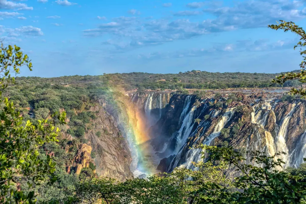
A small power station town on the Angolan border at the far western end of Omusati, with Ruacana Falls just west of it and the D3700 running on along the Kunene into Kaokoland.
Short answer
Ruacana is in Omusati, Namibia. This page lists 10 places to stay, 2 places to eat and drink and 4 sights.
- Places to stay
- 10
- Eat and drink
- 2
- Sights
- 4
- Where
- Omusati, Namibia17.44°S 14.36°E
In and around Ruacana
16 places listedWhere to stay in Ruacana 10
- 17.43°S 14.15°ECampsiteKunene Islands Camp+264 81 129 3931
- 17.43°S 14.43°EGuest houseMajuju GuesthouseRuacana, Namibia+264 81 147 7747
- 17.44°S 14.35°ECampsiteCamping SunsetRuacana
- 17.41°S 14.44°ECampsiteOkapika Camping+264 81 205 1784
- 17.41°S 14.22°ECampsiteHippo Pools Community Camp
- 17.50°S 14.35°EGuest houseOkamboola Lodge
- 17.42°S 14.16°ECampsiteOmunjandi Rest Camp
- 17.44°S 14.36°EHotelRuacana Eha Lodge
- 17.44°S 14.35°EGuest houseRuacana Guesthouse
Show all 10 places to stay
- Tjonkuvi Otjiruwo Camp · Campsite
Sights 4
 Ruacana FallsAttraction
- Kunene River ViewViewpoint
- Oiwo Canyon ViewpointViewpoint
- Upper ViewpointViewpoint
Restaurants and cafes 2
- HolibossCafe · regional, coffee shop, burger
- OkapikaRestaurant
Ruacana sits at the far western tip of Omusati, where the Ovambo farmland gives way to the hills of Kaokoland and the Kunene turns west to become the Angolan border. It was built in the early 1970s for staff of the hydroelectric scheme, and the underground power station is still why it exists. The 2023 census counted 5,939 people, split between the old NamPower village and Oshifo, 10 km east, which is now bigger and has the council offices and shops.
Getting there
Two tarred roads lead in. The C46 comes west from Ondangwa, and the C35 runs north from Kamanjab, which makes Ruacana an easy add-on to a trip through Etosha. Windhoek is about 757 km by road. West of town the D3700 is gravel. It passes the falls and follows the river to Swartbooisdrift and on to Epupa, and you need a 4x4 for it.
When to go
For most of the year the weir just above the falls sends most of the water into the power station, and the Calueque Dam upstream in Angola regulates the dry season flow, so you see a few streams running down bare rock. The falls only fill their 700 m wide gorge when the Kunene floods, roughly December to May, and March and April are usually the peak. It depends on rain in Angola, so nothing is certain. In a big year NamPower opens the sluices and the camps below the falls can flood; in April 2025 one was half under water and cut off.
What to do
The main viewpoint is close to the border post. Stairs to the west of it go down to the gorge floor and the ruins of the small first power station that ran the building work. The steps have been in poor shape for years (New Era reported it in 2019) and some have flooded, so go carefully. About 12 km west of town there is a pull-off with a short walk to a lookout over the weir and the falls. In the old village, look for half-moon corrugated iron bomb shelters left over from the border war in some backyards. Downstream, Hippo Pools is a community campsite on a sandbank under big mopane and leadwood trees, and Omunjandi, further west under jackalberry trees, arranges hikes and Himba village visits. Rafting trips run on the lower river.
Good to know
- Omusati is a malaria area, and the CDC recommends prescription tablets. See a travel doctor before you go.
- Fill up here, but do not count on it. In October 2022 one traveller found petrol but no diesel at both filling stations, so do not arrive on empty, and carry enough to get you through the river road west to Epupa.
- The Kunene has a lot of crocodiles. Do not swim in it.
History and culture
Ruacana is a power station town on the Kunene, where Ovambo farming country meets the Himba and Zemba cattle country of Kaokoland. Its story is about water and borders: a frontier Germany and Portugal could not agree on, a hydro scheme built by apartheid South Africa and Portugal, and a fortified army town close to one of the last big battles of the border war before Namibia's independence.
- Early 1800s
Portuguese traders set up a trading post on the banks of the Kunene and, according to Travel News Namibia, named it after the local Himba chief, Ruhacana. Their spelling of his name is the one the town still uses. source
- 1884 to 1915
Germany claimed South West Africa in 1884 but put its effort into the south and the coast, which offered better resources and trade, and left the Ovambo north largely undisturbed. A veterinary cordon, the Red Line, came to divide the settler south from the north. source
- 1926
The border here was argued over for decades. In 1926 a boundary convention meeting in Cape Town finally settled the line from the Kunene, using a beacon placed on the river bank in 1920. Under that agreement the falls lie entirely in Angola, although the river below them is the border. source
- 1964
Portugal, then ruling Angola, and South Africa signed agreements in Lisbon to dam the Kunene for power and water. Work on the Calueque Dam upstream started in 1972 and stopped in 1976, about 70 percent complete, because of the Angolan civil war. source
- Early 1970s
Ruacana town was built for staff of the South West Africa Water and Electricity Commission (today NamPower) and the Department of Water Affairs: 27 houses, a post office, clinic, filling station, shop, police station and sports ground. source
- 1970s to 1989
SWAPO (the South West Africa People's Organisation, the liberation movement) opposed the hydro scheme, which made it a target. The South African Defence Force turned Ruacana into a fortified settlement ringed with barbed wire and landmines against attacks by PLAN, SWAPO's armed wing. source
- 27 June 1988
After weeks of clashes between South African and Cuban forces in south-west Angola, eight Cuban MiG-23s bombed the Calueque dam and the bridge beside it. One bomb killed eleven young South African national servicemen. It was the largest direct clash between the two armies in the war, and the last South African troops left Angola by 1 September 1988. source
- 1999 to 2010
Ruacana was declared a settlement in 1999, a village in July 2005 and a town in September 2010. Its council and business centre is now at Oshifo, an Otjizemba word for green. source
- Peoples
- Ruacana is where cultures meet. Otjiherero-speaking Ovahimba, Ovazemba and Ovaherero live alongside the Eunda and the Onkolonkadhi, the westernmost and smallest of the eight Aawambo (Ovambo) communities. source
- Who lives here (2023 census)
- Ruacana Constituency, the town and the countryside around it, had 27,261 people in 2023. The largest group was the Ovadhimba and Ovazemba (6,326 people, about 23 percent), followed by the Aakwanyama (2,884), Aakolonkadhi (2,474), Ovaherero (2,291) and Aambalantu (2,203). The census counted 1,439 Ovahimba. source
- Language
- In the 2023 census the most common home language in Ruacana Constituency was Oludhimba (OtjiZemba), in 1,111 of 6,801 households, ahead of Oshikwanyama (831), Otjiherero (653) and Oshikolonkadhi (629). English, the official language, was the main home language in only 37 households. source
- Zemba dress
- The Ovazemba are semi-nomadic cattle herders who also grow millet and sorghum. Zemba women are recognised by their jet black hair, set off with tiny beads in white, red, blue and yellow, and by jewellery of iron and copper. source
For German visitors: The reason the falls are in Angola goes back to German rule. Germany and Portugal disagreed on exactly where on the Kunene the border line to the Okavango should start, and the dispute was never settled while South West Africa was German. source
For American visitors: The fighting at Calueque in 1988 happened while US-brokered peace talks were under way. Chester Crocker, Ronald Reagan's assistant secretary of state for Africa, had linked Namibia's independence to a Cuban withdrawal from Angola, and the deal was signed at the United Nations in New York on 22 December 1988. source
Main sights in Ruacana
5- Ruacana Falls viewpoint
Close to the border post. At full flood the falls are about 120 m high and 700 m wide; in the dry season only a few streams run down the rock face, and it is still worth the stop.
Travel News Namibia: Why Ruacana Waterfall (November 2024) - Gorge stairs and the first power station
Stairs west of the viewpoint lead down to the gorge floor and the ruins of the small first power station. The steps have long been in poor repair, and nobody has agreed who should fix them, so climb carefully.
New Era: Stairs at Ruacana waterfalls in state of disrepair (30 January 2019) - Weir lookout
About 12 km from town on the D3700, a short walk from a pull-off leads to a raised view of the diversion weir with the falls to its left.
Travel News Namibia: Why Ruacana Waterfall (November 2024) - The old NamPower village
Small enough to walk, with big mopane and purple-pod terminalia trees. Half-moon corrugated iron sections still standing in some backyards were once bomb shelters from the border war years.
Travel News Namibia: Why Ruacana Waterfall (November 2024) - Dorsland Trek memorial, Swartbooisdrift
West along the D3700, about 4 km past Kunene River Lodge, which is roughly 48 km along the gravel from the end of the tar. It marks the return in 1928 and 1929 of about 2,000 Dorsland (thirstland) trekkers from southern Angola to what was then South West Africa.
Travel News Namibia: Wilderness, waterfalls and wildlife (April 2019)
Did you know?
- There are two stories behind the name. Ovazemba oral tradition says it comes from a local leader called Ruhakana, while others derive it from the Otjiherero orua hakahana, the hurrying of the water. source
- Apart from its headbay, offices, workshops and power lines, the whole power station is underground. Building the machine and transfer halls and surge chamber meant removing 135,000 cubic metres of rock, and water drops to the turbines through four 140 m penstocks. source
- The first three 80 MW turbines were commissioned in 1978. In 2012 they were upgraded and a fourth added, taking the station to 347 MW, about half of Namibia's generating capacity. source
- Ruacana averages about 426 mm of rain a year, but in the 2010 to 2011 rainy season 960 mm fell. source
- In April 2025 NamPower opened the second sluice gate of the diversion weir and warned of a river flow not seen since 2011. Omunjandi rest camp (spelt Omanjandi in the report), about 8 km west of the falls, was half under water in what the camp said was its seventh flood. source
- Ruacana Constituency was created in 1998, when the town and the falls moved from Kunene Region into Omusati. The old Ruacana constituency in Kunene was renamed Epupa. source
Checked 10 October 2026.
The six miles nobody owned above Ruacana Falls
In 1920 a geology professor from Grahamstown published a plan to block the Kunene a little way above Ruacana and send it south. Ernest Schwarz of Rhodes University College had convinced himself that the river once spilled every year into the oshanas of Ovamboland and on into Etosha, and that it stopped only when it broke through the rock at what he called the Rua Cana Cataract and “hurried away to the sea”. Put a weir across it, he argued, and the old channels would fill, Etosha would become a lake again, and moist air off the water would bring rain to the whole country.
His book, The Kalahari; or, Thirstland Redemption, is free to read on the Internet Archive. He weighed up a cheap weir of driven piles packed with branches and rubble against a proper masonry wall, and put the wall in a rocky gorge six or seven miles above the smaller cataracts, where dirt lines on the rock showed floods had once stood forty feet over the dry season level. Ruacana itself he ruled out. It sits too far below the level of the plain. He also waved away anyone downstream who might lose their water: there were no people living between the falls and the sea, he wrote, and only mad ones would ever move there. The Himba who herd cattle along that stretch would have something to say about that.
Nobody built the weir. Fifty years later engineers did dam the Kunene above the falls, at Calueque, and a canal from it carries river water into Ovamboland. It stops a long way short of Etosha.
A strip run by two residents
Schwarz also explains, in passing, why the border here took so long to fix. The Germans and Portuguese had agreed on a line running due east from “the cataracts” of the Kunene. Portugal said that meant Ruacana, the big one. The Germans heard from their missionaries about smaller rapids higher up, at a place he spells Cambele, and claimed everything up to a line drawn from those. The difference was a belt about six miles (10 km) deep, running the whole length of the border.
When Schwarz travelled through, the question was still open. The belt was treated as neutral ground and administered jointly by a Portuguese resident and an English one. His host in Ovamboland, the Resident Commissioner Major C. N. Manning, had written what Schwarz called the only description of the Kaokoveld in existence, because the German map of the river below the falls was wrong enough to show that no one had been along it. The 1926 convention in the timeline further up this page ended it, and left the falls in Angola.
What the dam treaty actually says
The agreement that made the power station possible was signed in Lisbon on 21 January 1969, and the full text sits in an FAO collection of river treaties. Portugal let the pumping scheme at Calueque go ahead at once “on account of the humanitarian nature” of sending drinking water to people and cattle across the border. South Africa got the use of the regulated river from the weir basin to below the falls “in perpetuity”, and the ground it needed on the Angolan bank free of charge. In return it paid Portugal a royalty per kilowatt-hour on a set share of what Ruacana generated. Staff were to cross the border freely, with no immigration formalities, inside agreed limits.
That easy coming and going lasted about six years. On 9 August 1975, after armed groups had frightened the foreign workers at the site, a South African patrol crossed to occupy Calueque, and the army stayed for thirteen years. It was the first permanent posting of its regular units inside Angola. By June 1988 Ruacana was the headquarters of the task force facing the Cuban advance, under a colonel known as Mucho Delport. On 29 June, two days after the air raid, a company of 701 Battalion blew up the ramparts at the dam wall and became the last unit back over the bridge. The dam then sat broken until it was repaired between 2012 and 2015.
Bone dry, until the year it isn’t
One regular on the 4x4 Community forum is blunt about it: the falls are bone dry 99 per cent of the time, because the water goes through the turbines instead. In August 2019 he noted NamPower reporting 34 cubic metres a second, and reckoned that was too little to run all four turbines, never mind send anything over the lip. The treaty had assumed 80. Willie Olivier, writing in Travel News Namibia the same year, says the detour is hardly worth it when the river is low.
Then there are years like 2025, when the falls ran. New Era reported thousands of people there over Easter, roasting meat under the trees and dancing, and a reported 4,000 or so at the Hippo campsite. One woman who had come up from Otjiwarongo with her family told the paper the dry falls had kept them away in recent years.
Hippos, maybe, and five birds people travel for
The community campsite on the bank just below the power station is called Hippo Pools, and the name may be running ahead of the animals. A Travel News Namibia writer described that stretch as one hippos frequent, and the camp as a place to wake to the sound of them. That is one account and more than a decade old, so treat a hippo as a bonus. Crocodiles are the safer bet, and the reason nobody swims.
The birds are more dependable. The far north-west along this river is the only part of Namibia with Cinderella waxbill, a small grey finch found otherwise only in south-western Angola, and it is the southern limit of the rufous-tailed palm thrush, a bird of riverside palms whose loud whistling song comes mostly at dawn or dusk, sometimes as a duet. Grey kestrel and bare-cheeked babbler are on the same list. Birders tend to base themselves at a lodge about 48 km down the gravel towards Epupa, which runs birding cruises in the morning, and the keenest carry on into the Zebra Mountains for the Angola cave chat, first recorded in Namibia only in May 2010.
Map of Ruacana
See every place on this map as a list