Village · Kunene, Namibia
Twyfelfontein
A sandstone valley in southern Kunene with thousands of rock engravings made over several thousand years. Namibia's first World Heritage Site, seen with a local guide.
Short answer
Twyfelfontein is in Kunene, Namibia. This page lists 2 places to stay and 6 sights. The nearest park with an entry fee on this site is Palmwag Tourism Concession, about 122 km away, where international adults pay from N$100.
- Malaria
- Kunene is one of the Namibian regions where the CDC says malaria is transmitted and recommends preventive tablets.
- Places to stay
- 2
- Sights
- 6
- Park fee nearby: Palmwag Tourism Concession
- US$6 €5 · N$100about 122 km away
In and around Twyfelfontein
8 places listedWhere to stay in Twyfelfontein 2
 HotelTwyfelfontein Country Lodge
- 20.55°S 14.40°ECampsiteAba Huab Camp+264 81 129 0410
Sights 6
- Damara Living MuseumMuseum+264 81 650 8634lcfn.info
- Zieben Platten National Heritage SiteAttraction
- Old Farm HouseRuins
- Twyfelfontein Rock EngravingArchaeological site
- WondergatViewpoint
- Zeremonienplatz rock engravingsAttraction
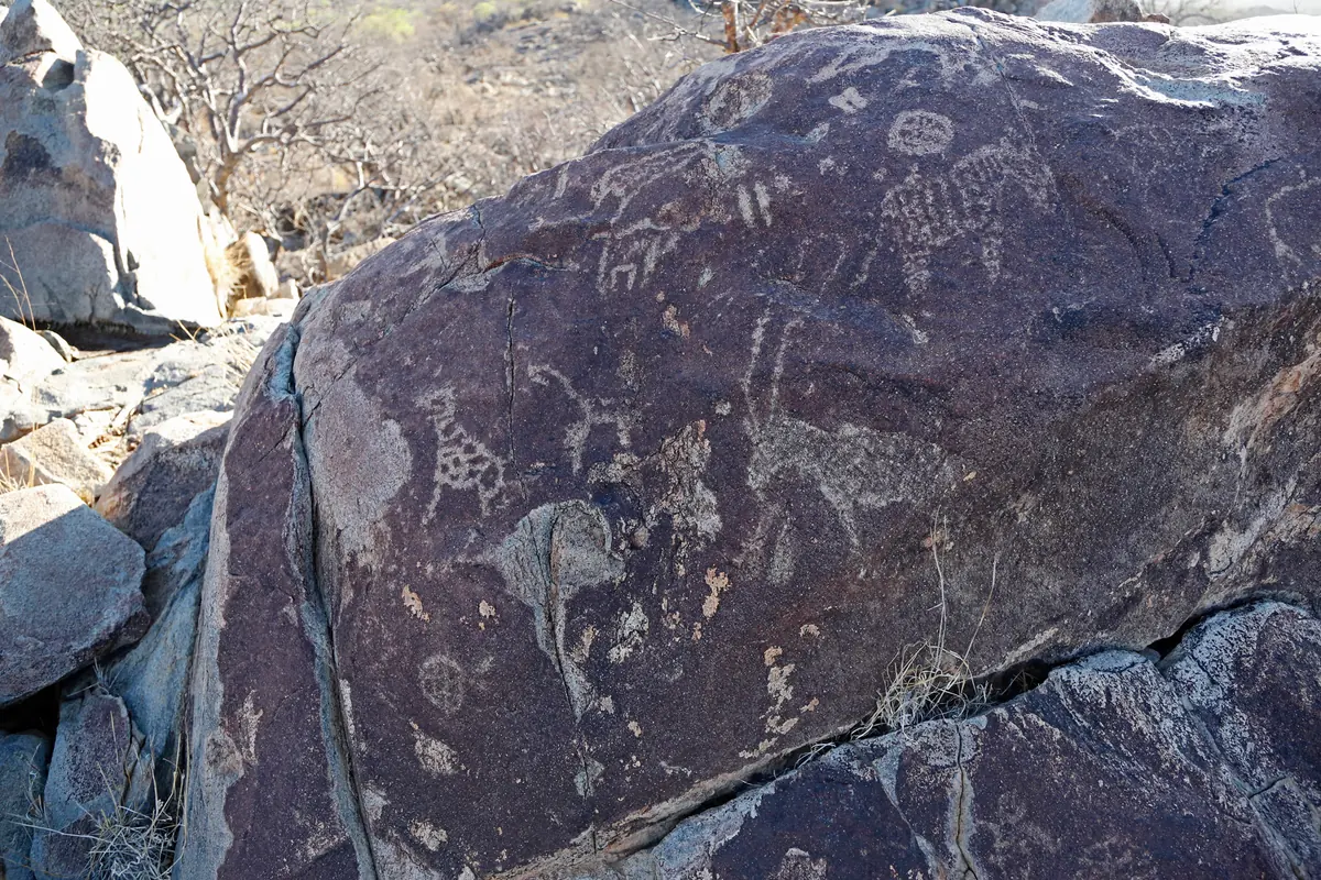
Twyfelfontein (ǀUi-ǁAis) is a dry valley below a red sandstone table mountain in southern Kunene, in the area most people still call Damaraland. Hunter-gatherers carved at least 2,500 animals, footprints and symbols into its rocks, the oldest of them thought to be around 6,000 years old, and Khoekhoe herders added their own later. In 2007 it became Namibia’s first World Heritage Site. There is no real village, just a visitor centre, a few lodges and campsites.
Getting there
From Khorixas, take the C39 west for about 72 km, turn left on to the D2612 for roughly 14 km, then right on to the D3254 for about 6 km and right again on to the D3214 for the visitor centre. Expect gravel west of Khorixas. Kunene’s gravel C roads are rough and corrugated but passable in an ordinary car, though some D roads in the region need a 4x4. The lodge has a gravel airstrip for fly-in guests.
When to go
Rain is under 150 mm a year and the days are hot for most of it. In July the valley runs from about 10 to 28 °C, in November from 21 to 35 °C. Go early in the morning. The valley is exposed, and soft morning light shows the engravings far better than the midday glare. The visitor centre is reported open daily from 08:00 to 17:00.
What to do
You see the engravings only on a guided walk, which starts at the visitor centre and usually takes half an hour to 80 minutes. The guide comes with the entry ticket, and a tip is expected. The famous panels are the Lion Man, a lion with a long kinked tail that ends in a six-toed paw print, and the Dancing Kudu. Early surveys also read a sea lion and penguins among the figures, more than 100 km from the coast, though later researchers doubt it. Allow two hours in all, with the walk from the car park.
Close by on the D3254, about 10 km to the south east, are Burnt Mountain, a lava hill whose reds and purples stand out at dusk, and the Organ Pipes, a cluster of basalt columns. The Living Museum of the Damara, opened in 2010 about 10 km north, runs a programme of roughly an hour and a half on old Damara ways: blacksmithing, leatherwork, dancing and games. Lodge drives head into the dry Aba Huab riverbed looking for desert elephants, which are not guaranteed.
Good to know
Fill up in Khorixas. One traveller reports a fuel pump run with the lodge, but treat it as a top-up, not a plan. Bring cash too, as the entrance is reported to be cash only and the nearest ATMs are in Khorixas or Swakopmund. The CDC recommends malaria tablets for Kunene, so see a travel clinic first. Aba Huab, the community campsite on the riverbed, cannot be booked ahead. Carry water on the walk, wear closed shoes on the rocky path and keep your hands off the engravings.
History and culture
Twyfelfontein (ǀUi-ǁAis) is a spring in a sandstone valley where hunter-gatherers and later Khoekhoe herders carved thousands of images into the rock over several millennia. Its recent past is part of Namibia's story too: a white farm in the late 1940s, a Damara homeland under apartheid, and since 1999 a community conservancy that shares in the visitors who come to see Namibia's first World Heritage Site.
- About 6,000 years ago
Stone Age hunter-gatherers of the Wilton culture settled the valley around its spring. They made most of the engravings and probably all of the rock paintings, as part of their rituals rather than as a record of hunting. source
- 2,000 to 2,500 years ago
Khoekhoe herders, a people related to the San, moved into the valley and called it ǀUi-ǁAis. Their geometric engravings, grinding hollows and game boards are clearly different from the older animal figures. New engraving probably ended around 1000 AD as pastoral peoples arrived. source
- 1921
Reinhard Maack, who had found the White Lady painting on the Brandberg, noted a mountain valley full of rock engravings in his field notes. The record was then largely forgotten for more than 20 years. source
- 1947
Drought-stricken farmers were granted farmland here, and the Nama and Damara speaking people who lived in the area were resettled near the Brandberg. David Levin became owner of the new farm in 1947 and named it Twyfelfontein because its spring did not flow all the time. source
- 1952
On 15 August 1952 the South West African administration declared the area a national monument. It stayed unguarded until 1986, when it was made a nature reserve, and many engravings were damaged or removed in that time. source
- 1965
The apartheid government bought the farm under the Odendaal Plan, its scheme of ethnic homelands for South West Africa, and the valley became part of the Damaraland homeland (Bantustan). The last white settlers left in 1965. source
- 1999
The Twyfelfontein-Uibasen Conservancy, a body through which local residents manage wildlife and tourism on their communal land, was registered in December 1999. It has 61 members and covers 286 km². source
- 2007
UNESCO inscribed Twyfelfontein (ǀUi-ǁAis) on the World Heritage List on 29 June 2007, Namibia's first site. The Namib Sand Sea followed in 2013. source
- Language
- In the 2023 census, 3,100 of the 4,321 households in Khorixas Constituency, which takes in Twyfelfontein, mainly spoke Khoekhoegowab at home, the click language of the Damara and Nama. Otjiherero was next, with 460 households. source
- The Damara
- The Damara (ǂNūkhoen in their own language) make up about 8.5 percent of Namibians and most live in the north west. They speak Khoekhoe like the Nama. Before 1870 they lived across much of central Namibia, hunting, herding sheep and cattle, growing crops and working copper. source
- Living Museum of the Damara
- Opened in February 2010 about 10 km north of the engravings, the Living Museum is a traditional Damara project where people show old crafts such as blacksmithing, leather tanning and jewellery making, along with dancing, singing and traditional games. source
- A community stake
- Since independence in 1990 local people have been trained as guides for the engravings, and the lodge, campsite and visitor centre are run as a joint venture between the lodge owners and the Twyfelfontein-Uibasen Conservancy, so visitors' money reaches the community. source
For German visitors: Reinhard Maack, who noted the engravings in 1921, was born in Herford in Westphalia in 1892 and came to German South West Africa in 1911 to work for the imperial land survey. His expedition diaries are owned by the town of Herford. source
For German visitors: Ernst Rudolph Scherz, who documented the engravings, worked on them from 1960 with German research funding, helped by his wife Anneliese, a professional photographer. source
For German visitors: Since 2017, research trips funded by the Deutsche Forschungsgemeinschaft have found up to 9,000 more rock images at 200 or more places along the Huab west of Twyfelfontein. SWR filmed the site for its Schätze der Welt series in 2008. source
For German visitors: The Living Museum of the Damara is backed by the Living Culture Foundation Namibia, a German and Namibian organisation that started in Tangermünde in Germany. source
Main sights in Twyfelfontein
4- Twyfelfontein rock engravings
Over 2,500 engravings on more than 200 sandstone slabs, plus a few rock paintings under overhanging rock. Seen only with a local guide from the visitor centre, which protects them from the theft and graffiti of earlier decades.
Wikipedia (German): Twyfelfontein - Burnt Mountain
A hill about 200 m high, about 10 km south east of the engravings on the D3254, where an 80 million year old lava flow shows red, brown and purple against paler rock. A national monument since 15 September 1956.
Wikipedia: Burnt Mountain (Namibia) - Organ Pipes
A cluster of basalt columns near Burnt Mountain, formed when molten rock pushed into slate and cooled, then laid bare by erosion. A short stop on the same road.
Wikipedia: Organ Pipes (Namibia) - Living Museum of the Damara
A traditional village where Damara people revive a culture that was largely lost under colonial rule, and earn a regular income for the community that built it. One of the Living Museums in Namibia backed by the German and Namibian Living Culture Foundation.
Living Culture Foundation Namibia (Living Museum of the Damara)
Did you know?
- The name means uncertain spring in Afrikaans. A friend teased David Levin, who kept worrying the spring would not water his herd, by calling him David Twyfelfontein, and Levin used the name when he registered the farm. source
- Sources disagree on what ǀUi-ǁAis means. Most give jumping waterhole, while the National Heritage Council translates it as a place among stones. source
- The best known engraving, the Lion Man, shows a lion whose long, kinked tail ends in a six-toed paw print, read as a person changing into an animal, part of shamanic ritual rather than a hunting scene. source
- Some rocks in the valley were used as gong stones and ring out with an unusual sound when struck. source
- In the 2009/10 tourism year 57,058 people visited the site. source
Checked 7 October 2026.
Wildlife you might see
8- possibleDesert elephantThe dry Aba Huab riverbed, best on a lodge drive. All year, never guaranteedsource
- possibleSpringbokTwyfelfontein-Uibasen Conservancy, which lists it among its key speciessource
- possibleOryx (gemsbok)Twyfelfontein-Uibasen Conservancy, which lists it among its key speciessource
- possibleKuduTwyfelfontein-Uibasen Conservancy, which lists it among its key speciessource
- possibleMountain zebraTwyfelfontein-Uibasen Conservancy, which lists it among its key speciessource
- possibleOstrichTwyfelfontein-Uibasen Conservancy, which lists it among its key speciessource
- possibleGiraffeAround the lodge in the Huab valleysource
- rareLeopardTwyfelfontein-Uibasen Conservancy, which lists it among its key speciessource
Likelihood is for a normal visit of two or three days, from the sources linked. Nothing is guaranteed in the wild.
Hikes and walks
1- Twyfelfontein rock engraving walk
Routes lead from the visitor centre over rough sandstone to the engraved slabs, where the Lion Man and the Dancing Kudu are the best known panels. Unguided walking is no longer allowed.
Permit: Guided only. The guide is included in the entry fee, and a tip is expected
Wikivoyage: Twyfelfontein
Staying safe in Twyfelfontein
- Malaria
- Kunene is one of the Namibian regions where the CDC says malaria is transmitted and recommends preventive tablets. See a travel clinic before you leave home and avoid mosquito bites, most of all from dusk. source
- Heat and sun
- The valley is hot and dry for most of the year. The engraving walk is on exposed rock with no facilities along the way, so go early, take water, a hat and sunscreen, and wear closed shoes. source
- Gravel roads
- The C39 is tarred from Outjo to Khorixas, but the road on west to Twyfelfontein is gravel, like the rest of Kunene's C roads, which are rough and corrugated. Some D roads need a 4x4, and in the rainy season whole areas can be cut off. source
- Desert elephants
- Elephants use the dry riverbeds around Twyfelfontein and the land is theirs. Keep at least 10 to 15 m away, and if one shakes its head, stay in the car, switch off and wait. source
- Drinking water and cholera
- The CDC lists Kunene as one of two Namibian regions with recent cholera cases. It is rare in travellers, but drink bottled or treated water and wash your hands before eating. source
Tips from travellers
- A traveller on a 4x4 forum reports a fuel station at Twyfelfontein, run with the lodge. Arrive with a full tank anyway and treat it as a top-up. one source
- Bring cash for the entrance, which is reported to be cash only, and a tip for your guide. The nearest ATMs are in Khorixas or Swakopmund. one source
- Allow about two hours at the site. The guided walk itself is usually 45 minutes to an hour, there is a walk of about 500 m from the car park to the reception, and the morning light is best for photos. one source
- Aba Huab, the community campsite on the dry riverbed, cannot be booked in advance. Most sites have water taps and fireplaces, there are thatched shelters for shade, and a bar sells cold drinks and snacks. one source
- The Living Museum of the Damara, about 10 km north of the engravings on the D2612, runs a village programme of around an hour and a half. You can stay longer if you like. one source
Checked 7 October 2026. Conditions change, so confirm with the park or venue before you go.
Map of Twyfelfontein
See every place on this map as a list