Town · Erongo, Namibia
Henties Bay
Quiet angling and holiday town at the Omaruru River mouth, 70 km north of Swakopmund, and the last place to fill up before the salt road up the Skeleton Coast.
Short answer
Henties Bay is in Erongo, Namibia. This page lists 23 places to stay and 8 places to eat and drink. The nearest park with an entry fee on this site is Dorob National Park, about 30 km away, where international adults pay from N$280.
- Malaria
- The CDC does not list Erongo, the region Henties Bay is in, among the Namibian regions where malaria is transmitted, and says it is rare elsewhere.
- Places to stay
- 23
- Eat and drink
- 8
- Park fee nearby: Dorob National Park
- US$17 €15 · N$280about 30 km away
In and around Henties Bay
32 places listedWhere to stay in Henties Bay 23
- 22.13°S 14.29°EChaletEagles Self-CateringJakkalsputz Road, Henties Bay+264 81 736 6601eagles.com.na
- 22.11°S 14.28°ECampsiteBuck‘s Camping LodgeHenties Bay+264 64 501 039
- 22.12°S 14.28°EHotelHuis KlipdriftKabeljou Street, Henties Bay
- 22.12°S 14.29°EGuest houseBeronnies B&BStrandhaai Street
- 22.13°S 14.29°EGuest houseFisherman's GuesthouseAuas St, Henties Bay+264 81 663 3679
- 22.09°S 14.26°ECampsiteIllofa Clan CampsiteHenties Bay
- 22.11°S 14.29°ECampsiteAnchors Campsite
- 22.11°S 14.28°EChaletBethesda
- 22.11°S 14.27°EGuest houseCilliers Vakansie
Show all 23 places to stay
- Desert Rendezvous · Guest house
- Die Blou Huis · Guest house
- Die Geel Huis · Guest house
- Die Oord · Guest house
- Eagle Holiday Flats & Backpacker · Hostel
- Elshoekie · Guest house
- Excalibur Rods & Reels · Guest house
- Gamsberg Accommodation · Hostel
- H&H Accommodation · Hostel
- Haus Estnic · Guest house
- Huis Hugo · Guest house
- Kuiseb Kaias · Guest house
- Lukzet Campsite · Campsite
- Namib Shore Bed & Breakfast · Guest house
Fishing spots 1
- Solitude Fishing AreaFishing spot
Restaurants and cafes 7
- Oom George se Coffee HouseCafe · coffee shop+264 81 662 0973
- De DuineRestaurant+2646450001
- Fishy CornerRestaurant · fish, fish and chips
- Misty Bay CafeCafe · Jakkalsputz Road, Henties Bay
- Pirate's PizzariaRestaurant · pizza
- The ClubhouseRestaurant · Jakkalsputz Road, Henties Bay
- The Coffee BarCafe · Jakkalsputz Road, Henties Bay
Bars and pubs 1
- Skubbe Pub & GrillBar · Karas Street, Henties Bay+264 64 501 373
Henties Bay (Hentiesbaai in Afrikaans) is a quiet holiday town on the Atlantic, 70 km north of Swakopmund and the northernmost town on the Namibian coast. It grew up around a freshwater spring in an old arm of the Omaruru River and it is still an anglers’ town first, with 7,569 people at the 2023 census and many more at Christmas. Most visitors treat it as the last stop before Cape Cross and the Skeleton Coast.
Getting there
The C34 has been tarred from Swakopmund to Henties Bay since 2019. North of town it is a salt road, which turns slippery when wet. Keep to 80 km/h and wash the underside of the car afterwards. The C35 heads inland past the Omdel Dam towards Uis. Fill up and buy water and food here, as there is little further up the coast.
When to go
It is cool all year: 20 to 30°C from December to March, the warmest months, and 14 to 18°C in the foggy months of August to October. In winter a hot east wind can bring two or three days of sandstorms. NWR opens its Jakkalsputz campsite south of town only in December and January. Anglers have traditionally rated late January to April for rock and surf fishing. The Henties Festival, built around an angling competition, draws crowds over a late August long weekend.
What to do
Fishing comes first. The angling spots are not marked and go by nicknames, many of them Afrikaans. Local operators run shark angling trips for copper sharks (bronze whalers), and every shark must go back into the sea alive.
On foot, the unmarked Jakkalsputz trail runs 18 km south from the Gallows along Solitude Bay (Farilhao Bay) to Jakkalsputz. Walk it at low tide, when the rock pools show. A 20 km route goes north up the beach to the Omaruru River mouth, up the riverbed and back across the desert plains. It is strenuous, so pick a cool, overcast day.
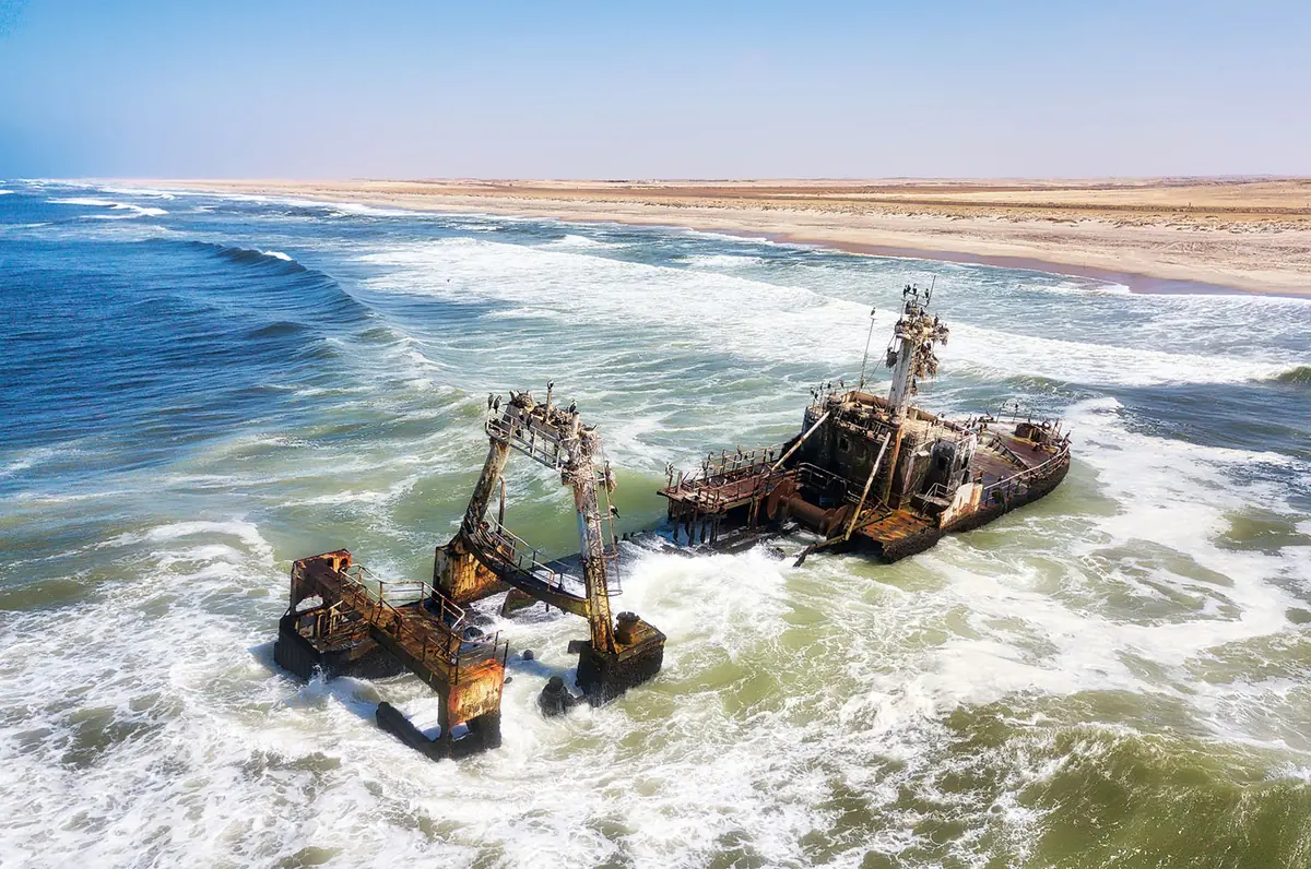
In town, the Gallows is a tree stump with a noose, put up in 1978 as a tongue-in-cheek warning to keep the beach clean. The nine-hole golf course in the Valley has grass greens and fairways of bare desert sand. The trawler Zeila has sat in the shallows about 14 km south since August 2008. North of town are the Cape Cross seal colony and the lichen fields, best seen early while the fog is in.
Good to know
Erongo is not one of the regions where the CDC recommends malaria tablets. It says malaria is rare outside those regions and advises only avoiding bites. The sea is 13 to 18°C with strong currents and whirlpools, so swim at the main beach in the Valley and stay shallow. Anglers need a fishing permit, and inspectors fine people for undersized or excess catches and for fishing in closed areas such as the Cape Cross reserve. Stay on existing tracks between the high-water mark and the road, where Damara terns breed. Out in the remote country around town there is no phone signal.
History and culture
Henties Bay is young by any measure. It began in 1929 when one man found a freshwater spring near the Omaruru River mouth and came back to build a holiday hut, grew into a shack town that the South African-run administration moved out of the riverbed, and only became a municipality in 1979. Its story is a small one about water, fish and holidays, set against the much larger history of German and South African rule over this coast.
- 1884
The territory became a German colony, German South West Africa (Deutsch-Südwestafrika), which lasted until 1915. Walvis Bay, to the south, stayed British as part of the Cape Colony. source
- 1904 to 1908
After the Herero rose against German rule in 1904, the German army carried out the genocide of the Herero and Nama. Swakopmund, 70 km south of today's Henties Bay, held one of the five main concentration camps. Germany acknowledged in 2015 that a genocide had been committed. source
- 1910
A 3.75 carat yellow diamond was reported found south of the Omaruru River mouth. Searches in the 1940s found no more south of the Ugab River, though prospectors kept trying into the 1960s. source
- 1915 to 1990
South African troops took the colony in the First World War, and South Africa then ruled it as South West Africa under a League of Nations mandate, later applying its apartheid laws there. source
- 1929
Hendrik Stephanus (Hentie) van der Merwe, a Kalkfeld car dealer who had served in the British army in the First World War, was hauling a rhino carcass from the Brandberg to the coast when his party, short of water, found a spring in a reed-filled valley south of the Omaruru River mouth. He came back at Christmas to build a simple hut and kept bringing friends and family. source
- 1951 to 1979
The South West Africa Administration let people rent plots in the riverbed in 1951, on condition that nothing permanent was built, so holidaymakers put up shacks of wood and hardboard. In 1966 they were moved out and 27 people could buy plots on the dunes either side; the De Duine Hotel opened in 1967, and the town became a municipality on 1 August 1979. source
- 1966 to 1990
SWAPO (the South West Africa People's Organisation) launched its armed struggle against South African rule in 1966, part of the wider South African Border War. Namibia became independent on 21 March 1990. source
- 1992
In the town's first local election after independence, SWAPO narrowly won, taking four of the seven council seats to the DTA's three. source
- Language
- At the 2023 census the most common home languages in Erongo Region households were Oshikwanyama (20.2%), Afrikaans (19.9%) and Khoekhoegowab, the language of the Nama and Damara (15.6%), followed by Oshindonga (11.1%), Otjiherero (9.4%) and English (6.2%). source
- Angling
- Fishing made the town. The early anglers used a hand line on a stick, a piece of chain as a sinker and nails for hooks. Today's spots are not marked and go by nicknames such as Bennie se rooi lorrie (Bennie's red lorry) and Sarah se gat (Sarah's hole). source
- Henties Festival
- Local businesses started the festival to bring people in during the quiet months of June to August. It is held over the long weekend in late August, with music, stalls and the Henties Bay Angling Club's competition at its centre. source
- A holiday town
- Henties Bay began as a pure holiday resort and has since become a place people live, but its population can still triple over Christmas and New Year. source
For American visitors: The town owes its start to an American museum. The rhino skeleton Hentie van der Merwe hauled to the coast in 1929 was wanted by a museum in Pennsylvania, and after his party found the spring it was taken on to Swakopmund and shipped to the United States. source
For German visitors: At the spring, van der Merwe found traces of an earlier camp and an old metal sign in German saying diamonds had been found there. He thought Schutztruppe soldiers (the German colonial army) might have camped there on an expedition in 1886. source
For German visitors: Some German speakers still call the town Hentiesbucht, its German name, alongside the Afrikaans Hentiesbaai. source
For German visitors: In the early shack years the only shop belonged to a German named Köstens, who sold basics such as rice, sugar, flour, tinned food, coffee and paraffin. source
Main sights in Henties Bay
5- The Gallows
A tree stump with a rope and noose that early residents Frank Atkinson and Willie Cilliers put up in 1978 as a 'friendly but firm' warning to keep the town and beach clean. The municipality added a plaque in 2001, and it is probably the most photographed thing in town.
Henties Bay Tourism Association, To see in Henties Bay (archived copy, 2019) - The fountain in the Valley
The freshwater spring almost on the beach, in an old arm of the Omaruru River that splits the town into the North Dune and the South Dune. It is the reason Henties Bay exists.
Henties Bay Municipality, About - Zeila shipwreck
A fishing trawler sold for scrap that broke loose from its tow soon after leaving Walvis Bay and ran aground near Die Walle, a fishing spot about 14 km south of town, on 25 August 2008. Its hull is still visible.
Republikein, Tourist attraction (19 August 2019) - Omaruru River and Omdel Dam
The Omdel Dam lies in the Omaruru River about 30 km out on the C35 to Uis, in the river's old sand and gravel deltas. The underground water stored there helps supply Henties Bay, Swakopmund, Arandis and Walvis Bay. There are picnic sites, and the birding is good when the dam holds water.
Travel News Namibia, Henties Bay (July/August 2004) - Cape Cross
North on the C34, where the Portuguese navigator Diogo Cão set up a cross in 1486, and where a colony of Cape fur seals breeds. It has its own page on this site.
Travel News Namibia, Henties Bay (July/August 2004)
Did you know?
- Hentie van der Merwe went after the rhino because a museum in Pennsylvania wanted a skeleton and was offering up to £800 for one. source
- Van der Merwe's first shack was built from the wooden crates that imported cars arrived in. source
- In the early 1960s prospectors dug for diamonds just south of town. Five stones were said to have been recovered, rumour had it they were planted, and the mine closed in 1971. source
- The golf course in the Valley has grass greens and tees, but its fairways are bare desert sand. It has nine holes over 2.7 km. source
- In March 2026 an opposition MP proposed renaming the town Sam Nujoma Bay, noting that Namibia's founding president was born in 1929, the year Henties Bay was founded. source
Checked 7 October 2026.
Wildlife you might see
6- very likelyCape fur sealThe breeding colony at Cape Cross, north of town on the C34source
- likelyCormorantsNesting on the wreck of the Zeila, about 14 km south of townsource
- possibleCopper shark (bronze whaler)Off the beaches, on shark angling trips with local operators; every shark must be released alivesource
- possibleSilver kabeljou, west coast steenbras, galjoen and blacktailRock and surf angling spots north and south of town. Traditionally late January to April, though regulars fish all yearsource
- possibleBlack-backed jackalIn the desert around town; leave them alone, as they matter to the desert's ecologysource
- rareDamara ternBreeds on the ground between the high-water mark and the coast road; keep to existing trackssource
Likelihood is for a normal visit of two or three days, from the sources linked. Nothing is guaranteed in the wild.
Hikes and walks
2- Jakkalsputz Walking Trail
Unmarked walk from the Gallows at the south end of town along Solitude Bay (Farilhao Bay), ending at Jakkalsputz, so plan how you get back. Go at low tide, when the rock pools show.
Permit: No permit mentioned in the published trail details
Travel News Namibia, Hiking and backpacking in Namibia (August 2013) - Omaruru River Walking Trail (short route)
North along the beach to the Omaruru River mouth, up the riverbed and back to town across the desert plains. It is strenuous, so pick a cool, overcast day.
Permit: No permit mentioned in the published trail details
Travel News Namibia, Hiking and backpacking in Namibia (August 2013)
Staying safe in Henties Bay
- Malaria
- The CDC does not list Erongo, the region Henties Bay is in, among the Namibian regions where malaria is transmitted, and says it is rare elsewhere. It recommends tablets only for the listed regions in the north and east, such as Kunene, the Kavangos and Zambezi, and bite precautions anywhere else. If you drive on north into Kunene, take advice before you go. source
- Sea
- The water is 13 to 18°C and the current is strong, with whirlpools in places. Swim at the main beach in the Valley and do not go out deep unless you are a strong swimmer. source
- Salt and gravel roads
- North of Henties Bay the C34 is a salt road, slippery when wet. Keep to 80 km/h on gravel, lower your tyre pressure, and carry a spare tyre and a jack that works. source
- Desert trips
- Before heading into the desert inland, check you have drinking water, enough fuel, tools and spare tyres, plus warm clothes and sun protection. There is no phone signal in the remote country around the town. source
- Camping in the open
- Sleep in your car or a tent, never in the open, as hyenas have attacked people sleeping out. Do not camp within 2 km of an open waterhole. source
- Valuables
- The tourism office calls the town one of the safer places in Namibia but says thieves are active at night and opportunistic. Do not leave valuables in the car or under an open window, and lock up at night. source
Tips from travellers
- Get a fishing permit before you cast. No angling is allowed inside the Cape Cross Seal Reserve, and every shark you hook must go back alive. official
- Read the angling regulations. Heavy fines are handed out for undersized mussels, having bristle worm, fishing in closed areas and keeping more than the limit, and South African visitors are regularly fined at roadblocks and borders. official
- Fill up with fuel and buy food, water and anything else you need in Swakopmund or Henties Bay before going north. Supplies up the Skeleton Coast are very limited. several sources
- NWR's Jakkalsputz campsite opens only in December and January. Bring your own power, as the sites have none. official
- For the lichen fields north of town, go early while the fog is still in, or sprinkle a little water on them, to see the colours. one source
- Wash the underside of your car after driving the salt road north of Henties Bay. one source
- Keep to existing roads and tracks. Do not drive on the lichen fields or gypsum plains, and stay on tracks between the high-water mark and the road, where Damara terns breed. Do not take plants, stones or wood from the desert. official
Checked 7 October 2026. Conditions change, so confirm with the park or venue before you go.
A dam that feeds the sand, and a fish that changes sex
In the third week of January 2004 NamWater’s office in Swakopmund was watching a river. The Omaruru had come down in flood and was running somewhere between Okombahe and Uis, and what the staff wanted to know was whether it would get as far as the Omdel Dam, about 30 km out of Henties Bay on the Uis road. One of them, Hendri Opperman, told The Namibian that the riverbeds were already wet and muddy from the first floods, so the water should now travel faster. The hope was for the dam, not the sea. On this coast a river that reaches the Atlantic is water lost.
A dam built to be emptied into the sand
Under the lower Omaruru lie deep channels left by a much older river and long since filled in. They hold fresh water, and by the 1980s the coastal towns and a big uranium mine were pumping it at close to twice the safe rate. Water levels had dropped by tens of metres.
A research project begun in 1988 asked whether the aquifer could be topped up by hand, and the Omdel scheme was built between 1991 and 1995. The dam can hold 41 million cubic metres, but the point is to get rid of it. Floodwater is kept only until the mud has settled out, then let go to a string of basins in the riverbed 6 km downstream, sited where today’s river crosses the buried channels. There it soaks away. The basins are cleared of silt twice a year.
Eberhard Braune and Sumaya Israel, who wrote the scheme up for the Groundwater Project, give the tally. In the 22 years from 1994 to 2016 the lower river flooded in six periods, and only three did the aquifer much good. Even so they credit Omdel with nearly doubling what can safely be pumped, and with putting off a large desalination plant. So a dry dam on the C35 is not a broken one.
The president who kept dropping in
The University of Namibia campus started in 2002 with two buildings and is named after Sam Nujoma. It now has more than 200 students, and its director says at least 70% of its graduates have gone into the fishing sector or the ministry. Staff told New Era after Nujoma’s death in 2025 that the call would come early in the morning: the founding president was in Henties Bay and wanted to pay a visit.
His subject was water. In May 2019 he launched a small desalination plant on the campus that runs entirely on solar power, a joint project with the University of Turku in Finland, and the university set aside two hectares of its own sand for olive trees on drip irrigation from it. In June he was back, citing a university study of a full-size plant somewhere between here and Swakopmund: about 40 million cubic metres a year, pumped some 1,700 m uphill to supply the central network and Windhoek. He asked the government to make it a national priority. In the same speech he spoke of the Omdel aquifer as “drying up”.
A kob with no smell and a steenbras that changes sex
The fish that fills cooler boxes here had no scientific name of its own until 1995. That year Marc Griffiths and Phil Heemstra described the silver kob as a species and called it inodorus, “without scent”, because its relative the dusky kob gives off a brassy smell and this one does not.
Namibia’s kob make a long round trip. Adults swim south at the start of summer, against the current, to spawn at Sandwich Harbour and Meob Bay between October and March. The larvae are thought to drift back north, and at about two years old the young fish start working up towards the feeding grounds off the Skeleton Coast park.
The west coast steenbras is stranger. Every one begins as a male. The northern fish, the ones caught off these beaches, mature at nearly five years old and only become females at about seven, so the breeding females are the older fish. It lives in the surf, usually in less than 10 m of water, is uncommon outside Namibia and is listed as Endangered. The bronze whaler is slower still. Off South Africa, where it has been aged, a male needs 13 to 19 years to mature and a female about 20, and she has a litter only every second year. A shark that slow is easily fished out, which makes sense of the rule that every one goes back alive.
What the regulars say, and a hill worth stopping for
On the 4x4 Community forum the fishing talk is unsure of itself. One man with about ten trips behind him wrote that locals rate the full moon as the worst time, whatever the tide charts say, and that fish bite at any hour when they are moving along the coast. His own report from Sarah se Gat in November 2021 was that fishing was poor “but some of us were lucky”. Another poster said the blacktail and steenbras had turned up late in 2024, and hoped the next visitor would not get a red tide. These are single anglers’ accounts, and none of them promises you a fish.
Many of the fishing spots are named for their distance in miles from Swakopmund. Across the road from the salt pan just north of Mile 72, about 44 km from town, is Lagunen Hill, on the east side, where the black rock is crusted with lichen in green, orange and grey. Much further up, 23 km past Mile 108 according to Travel News Namibia, lie pieces of the Winston, a fishing vessel that ran ashore in 1970.
For anything with hooves you have to turn inland. A 2001 account of the country behind Henties Bay lists springbok, gemsbok, steenbok, ostrich and Hartmann’s mountain zebra on the plains and dry watercourses of the Ugab, and welwitschias near the Messum Crater carbon-dated at 1,000 to 1,500 years old.
Quick answers
What animals can you see in Henties Bay?
Most visitors see cape fur seal. You have a good chance of seeing cormorants. Damara tern is there but rarely seen.
What are the best hikes in Henties Bay?
Jakkalsputz Walking Trail (18 km) and Omaruru River Walking Trail (short route) (20 km). See the hikes section for times, difficulty and permits.
Map of Henties Bay
See every place on this map as a list