District · Botswana
Central District
Botswana's biggest district, from the Limpopo and the Tuli Block up to Sua Pan. Serowe and its rhino sanctuary, the Tswapong Hills, Kubu Island and the flamingos at Nata.
Short answer
This page covers 4 parks and reserves and 11 towns and cities in Central District. 2 of the parks have checked entry fees: international adults pay from P117.2 at Khama Rhino Sanctuary to P190 at Makgadikgadi Pans National Park.
- Parks and reserves
- 4
- Towns and cities
- 11
- Places to stay
- 52
- Where
- Botswana21.48°S 25.91°E
Parks and reserves in Central District
4Towns and cities in Central District
11Central District is the biggest piece of Botswana, 147,730 km² running from the Limpopo on the South African border up to the salt of Sua Pan. Serowe is the capital and the seat of the Bamangwato, the Khama family’s people. Close to three in ten Batswana live here (706,135 at the 2022 census). Most visitors only see it through a windscreen on the way to Maun or Kasane, which is a waste.
Getting there
The A1 from Gaborone to Francistown is the spine. Palapye sits roughly halfway, 240 km from Gaborone and 170 km from Francistown, and it is where you turn off for Serowe. Buses between the two cities leave about hourly.
For the north, take the A3 from Francistown to Nata, where the road forks for Maun and Kasane.
The Tuli Block is easier from South Africa through Pont Drift, about six and a half hours from Johannesburg. You cross the Limpopo by vehicle when it is low and by cable car when it is in flood.
When to go
April to October is dry, and May to late August is winter, with cold winds. Rain falls between November and March. Sua Pan fills in summer and holds Nata River water until April or May. The flamingos come to Nata to breed after the rains. Kubu Island has closed after heavy rain before, so ask the trust before you set out.
What to do
Khama Rhino Sanctuary, about 25 km from Serowe, has white and black rhino on 8,585 hectares of Kalahari sandveld. Its roads suit two-wheel-drive bakkies, and rangers run two-hour game drives and morning rhino tracking. Serowe itself has the Khama III Memorial Museum.
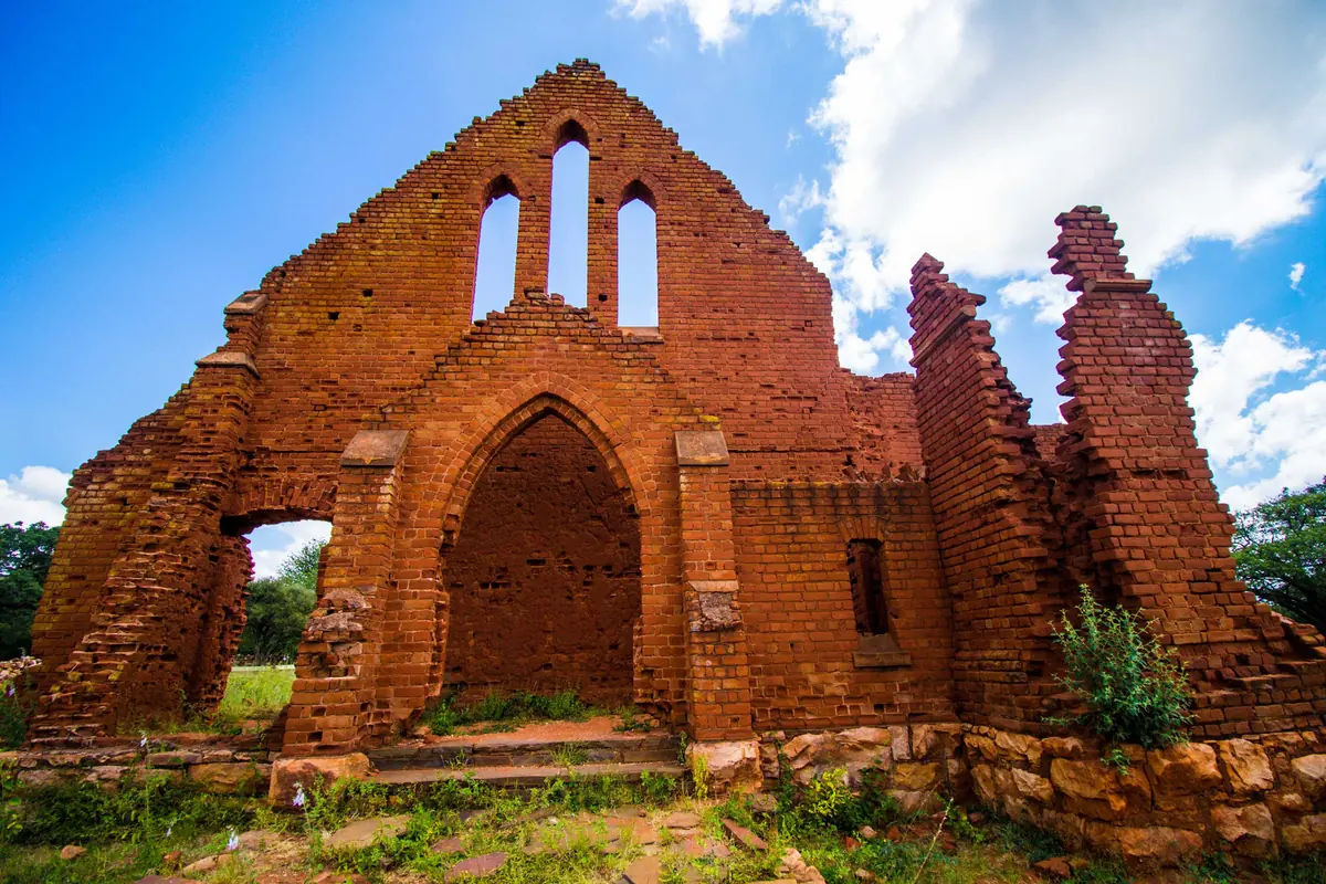
Near Palapye the Tswapong Hills run for about 63 km. Rain seeps back out of the cliffs, so the gorges keep pools all year. Moremi Gorge is the main draw, and Cape vultures breed in the hills. Old Palapye has the ruin of a London Missionary Society church, built around 1892 and abandoned in 1902.
Kubu Island is a granite outcrop in Sua Pan, a national monument with old stone cairns and a low dry-stone wall. The Gaing O Community Trust, based in Mmatshumo, runs the campsite and can send a guide to walk you round.
Nata Bird Sanctuary, about 15 km from Nata, covers 230 km² and is run by four villages. A raised wooden platform looks out over the pan.
The Tuli Block has elephant, lion, leopard and cheetah, and Solomon’s Wall, 30 m basalt cliffs on the Motloutse River. Nearly all of it is private game farms and reserves, though. Without a lodge booking you are limited to the main road.
Good to know
- The CDC lists Bobirwa, Boteti, Mahalapye, Serowe/Palapye and Tutume as malaria areas and recommends prophylaxis.
- Livestock and wildlife wander onto the tar. The UK government singles out night driving as a particular risk.
- Kubu needs a 4x4. Rural tracks are not signposted, so take a GPS, a spare tyre, and enough fuel and water to reach the next stop.
- On Kubu, register on arrival. Driving off the tracks is banned.
In and around Central District
86 places listedWhere to stay in Central District 52
- 20.47°S 25.13°EHotelCamp Kalahari+27 21 001 1574naturalselection.travel
- 19.75°S 26.07°EHotelElephant Sands Lodge+267 73 445 162
- 23.00°S 27.94°EHotelKwa Nokeng Lodge+267 491 5908kwanokeng.com
- 20.99°S 24.36°ECampsiteRakops River LodgeRakops
- 20.84°S 25.82°ECampsitePan Ranger Staff Camp
- 22.83°S 28.06°ECampsiteAfrica Ranch
- 20.87°S 27.17°ECampsiteBush Buck
- 22.59°S 28.52°EHostelCharley's Lodge - Private Site 2
- 22.46°S 28.60°EHotelCommercial Lodge Site
Show all 52 places to stay
- Home ft · Chalet
- Island Lodge · Hotel
- Jack#s Camp · Hotel
- Jeer Guesthouse · Guest house
- Kirkia Camp · Hotel
- Kwadiwa Campsite · Campsite
- Kwadiwa Ranch · Resort
- Lephale Lodge · Hotel
- Limpopo River Lodge · Campsite
- Limpopo River Lodge · Resort
- Lipadi Rock Lodge · Hotel
- Makadibeng Cattle Post · Hotel
- Marula Tented Camp · Hotel
- Molema Bushcamp · Campsite
- Oasis Lodge Chalets Zanzibar · Chalet
- Oasis Lodge Zanzibar · Guest house
- Pan Ranger Campsite - Public · Campsite
- Private Site 1 · Hostel
- Private Site 10 · Hostel
- Private Site 11 · Hostel
- Private Site 12 · Hostel
- Private Site 19 · Hostel
- Private Site 20 · Hostel
- Private Site 21 · Hostel
- Private Site 3 · Hostel
- Private Site 4 · Hostel
- Private Site 5 · Hostel
- Private Site 6 · Hostel
- Private Site 7 · Hostel
- Private Site 8 · Hostel
- Private Site 9 · Hostel
- River Camp · Hotel
- River Camp Central Facility · Hostel
- River Camp Unit 1 · Hostel
- River Camp Unit 2 · Hostel
- River Camp Unit 3 · Hostel
- River Camp Unit 4 · Hostel
- River Camp Unit 5 · Hostel
- River Camp Unit 6 · Hostel
- River Camp Unit 7 · Hostel
- San Camp · Hotel
- Stevenford Gamereserve · Campsite
- Wilderness Tented Camp · Hotel
Sights 33
 Chapman's BaobabAttraction
- Big Baobab TreeViewpoint
- CrocodilesViewpoint
- Elephant Castle AreaZoo
- Giant Baobab TreeAttraction
- Grass PlainAttraction
- Green's BaobabAttraction
- Harry's CampViewpoint
- Hills side c1Attraction
- Hippo PoolsViewpoint
- Hyena DenCave
- Klopper HouseRuins
Show all 33 sights
- Kubu Island · Viewpoint
- Limpopo River Viewpoint · Viewpoint
- Modimotsebe Cattle Post · Attraction
- Old Grader · Viewpoint
- Old Maritz Farm · Ruins
- Olehile corner D · Viewpoint
- Possible Aardwolf Den · Cave
- Possible Den · Cave
- Possible Hyena Den · Cave
- Potholes Entrance · Viewpoint
- River Viewpoint · Viewpoint
- Roam Rock · Viewpoint
- Shooting Range · Viewpoint
- Sipping Pools · Viewpoint
- Sipping Pools · Viewpoint
- Sundowners Spot · Viewpoint
- Thune Dam View Point · Viewpoint
- Top corner C-hills · Viewpoint
- Tropic of Capricorn · Monument
- Tune dam nice side · Attraction
- Zebra Waterhole · Attraction
Restaurants and cafes 1
- Resort restaurantRestaurant
Map of Central District
See every place on this map as a list