Village · Kgalagadi District, Botswana
Kang
A Kalahari village of 6,764 people halfway along the Trans-Kalahari Highway, used for fuel and a bed between South Africa and Namibia and as the last sure fill-up before the Kgalagadi park.
Short answer
Kang is in Kgalagadi District, Botswana. This page lists 12 places to stay and 2 places to eat and drink. The nearest park with an entry fee on this site is Khutse Game Reserve, about 141 km away, where international adults pay from P190.
- Places to stay
- 12
- Eat and drink
- 2
- Park fee nearby: Khutse Game Reserve
- US$14 €13 · P190about 141 km away
- Where
- Kgalagadi District, Botswana23.67°S 22.79°E
In and around Kang
14 places listedWhere to stay in Kang 12
- 23.68°S 22.79°EGuest houseGoo Baitshepi InnKang
- 23.68°S 22.77°ECampsiteKang Ultra Stop
- 23.66°S 22.80°EGuest housePalm View Guest HouseKang
- 23.68°S 22.81°EHotelAccomodation Nakabu Selected Hotel
- 23.68°S 22.77°ECampsiteCampsite Kang Ultra Stop
- 23.68°S 22.77°EHotelEcho Lodge
- 23.68°S 22.77°EHotelJuliet Hostel
- 23.69°S 22.80°EHotelKang Lodge
- 23.68°S 22.76°EMotelNakabu Hotel
Show all 12 places to stay
- Stonehouse Nkise · Guest house
- VDC Guesthouse · Guest house
- Yame Kele Guesthouse · Guest house
Restaurants and cafes 1
- Nkise Restaurant & BarRestaurant
Bars and pubs 1
- Kings & Queens BarBar
Kang is where you stop on the Trans-Kalahari Highway. It sits in the Kalahari at about 1,130 m, roughly halfway along the A2 between the South African and Namibian borders, and close to halfway between Pretoria and Windhoek. The 2022 census counted 6,764 people, up from 5,985 in 2011. Nobody plans a holiday around it. People pull in for fuel, food and a bed, and those heading for the Kgalagadi Transfrontier Park turn off here.
Getting there
The A2 is tar all the way, 762 km from Pioneer Gate near Lobatse to Buitepos, and an ordinary car manages it. From Gaborone you come through Kanye, Jwaneng and Sekoma, which is about 150 km before Kang. Ghanzi is around 250 km further on to the north-west. The tar road to Hukuntsi leaves the highway at Kang and runs about 110 km west. Kang also has an airstrip, on the Tsetseng road.
When to go
If you have a choice of dates, the cooler months are kinder for a long day in the car. Out here winter nights get very cold and summer days very hot. The district’s rain, about 250 mm a year, falls mostly between November and May.
What to do
Refuel and sleep. Kang Ultra Stop on the highway is the usual place, with fuel, a shop that stocks more food than you would expect, chalets and camping.
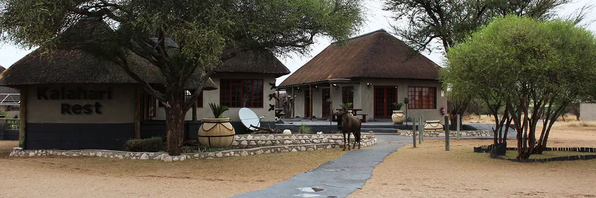
If you would like the stop to feel like part of the trip, Kalahari Rest is the one overlanders keep naming. It is a private game lodge about 25 km up the highway towards Ghanzi, with chalets, campsites, a restaurant, a bar and a pool. It runs game drives early in the morning and late in the afternoon, and lists giraffe, eland, zebra and kudu on the property, with cheetah, leopard and brown hyena about as well.
Kang is also the northern way into the Mabuasehube side of the Kgalagadi Transfrontier Park. After the tar to Hukuntsi it is another 140 km to the gate, sand and gravel mixed, and that part is for a 4x4 only.
Good to know
Fill up here whichever way you are going. Hukuntsi has a filling station, but people who drive the route regularly say Kang is the more dependable of the two, and there is no fuel in the park. On the highway itself the pumps are far apart. A truck driver told the Daily News in 2022 that he wanted a station between Sekoma and Kang and another between Kang and Ghanzi, and that there is no phone signal if you get stuck in between.
Do not drive this road after dark. Livestock and wildlife wander onto the tar. Truckers interviewed for the same article called animals their biggest problem on this highway, and the UK government’s travel advice says the risk is worst at night.
Malaria is barely a concern. The CDC records only rare cases in Kgalagadi North and recommends bite avoidance, not tablets. Ghanzi District, further up the road, is on its list of transmission areas, which matters if you carry on north.
Thirty runaway oxen and one well: Kang before the tar
In November 1894 about thirty trek oxen broke away from a police post out in the Kalahari, far to the north of Kang. They were the fat ones, held back for the long wagon haul across the Kalahari to Mafeking. Riders followed the spoor north to a pan, saw it swing south at a full gallop, and gave up the chase. The oxen turned up at Kang, roughly 260 km from that pan in a straight line, with no water anywhere on the way and the worst heat of the year under way. More than two thirds were dead. The Bakgalagadi living at the well said the first animals to arrive had thrown themselves into the well pit and been trampled by those shoving in behind. Siegfried Passarge, the German geologist who wrote the story down in Die Kalahari (1904), used it to show how far thirsty animals will travel. He also remarked that the villagers had most likely slaughtered the animals themselves.
The pan that made the village
That well is the reason Kang is where it is. Passarge lists Kang among the big brackish pans on the wagon roads from Mafeking, Kanye and Molepolole to Ghanzi, each with a well fed by a spring in the limestone floor. Villages along the Molepolole road had nothing but suck-wells, hollows where the damp in the sand was drawn up through a tube. A study of Bangologa settlement in the University of Botswana’s journal Pula names Kang as one of the pan-side sites those herders lived at and then left, moving after water and grazing before they settled around Hukuntsi. The village still sits beside its pan.
Kang has another name. In ǃXóõ it is ǀná̰m, a word that opens with a click. ǃXóõ, also called Taa, had about 2,500 speakers in 2011 and may carry more distinct sounds than any other language on record. The linguist Anthony Traill studied it with speakers at Lone Tree, up the highway towards Ghanzi.
A tightrope walker digs for water
The oddest visitor on record is William Leonard Hunt, a Canadian who walked a high wire over Niagara in 1860 and performed as the Great Farini. In 1885 he took wagons into the Kalahari with his adopted son Lulu, a former acrobat who came along as photographer. His book says they reached a place his guides called Kang Pan at about nine one morning after days of living on tsamma melons, and found it had just dried up. They dug a pit four feet deep in the mud and got a foot of milky water. Across the pan stood empty shelters, and melon vines already picked clean. On the way in they had outspanned under a sociable weaver nest that Farini put at nearly six feet thick. That same night, a few hours’ trek beyond the pan, by his telling a lion crashed into the circle round the camp fire, mauled one of his men, Klas, jumped on a wheel ox and was shot through the eye by Lulu.
Read him with care. A.J. Clement went through the journey in 1964 and concluded Farini never got as deep into the desert as he said. The lion may belong with his “lost city”. The dry pan and the digging sound like someone who had done it, though a day after the lion he has the wagons in sight of Lehututu, which is a long way west of the Kang on today’s map. Farini also mentions a trader named Harris killed at Kang Pan some time before, which is his word alone.
A better witness is Livingstone, who late in 1852 met a traveller named McCabe coming back from Lake Ngami. McCabe had struck straight across the desert from south of Kolobeng in a year of unusually heavy rain, and his cattle went 21 days on wild melons and nothing else. Farini had heard the same story thirty years on, as nineteen days without water between Ghanzi and Kang Pan.
Sand to the diffs until 1995
A member of the 4x4 Community forum who went up to Ghanzi with his father in school holidays in the 1970s remembers the tar ending about 15 km out of Lobatse and the sand starting some 25 km beyond Kanye. Their 1969 Ford F250 dragged both diffs along the middle ridge of the track, and nobody talked about kilometres, only hours.
The 161 km from Sekoma to Kang were finished in June 1995, paid for by an Arab development bank and the Kuwait Fund. Kang to the Ghanzi junction followed in September 1997. The planners chose to leave most of the road unfenced so that game and cattle could keep crossing, and the evaluation written afterwards admits what that meant: animals standing on the tar, and crashes.
What you will see, and what you won’t
Kang is not a wildlife stop. The game people talk about is on Kalahari Rest, the private game lodge up the highway, and its own species list gives the game away: waterbuck and impala do not belong in dry Kalahari sandveld, so some of what you see was presumably brought in. As for the predators it mentions, leopard and brown hyena keep to the dark and cheetah are thin on the ground anywhere, so I would not count on any of them. Campers who stop there write mostly about the quiet and the sunsets, and one poster warns that the stop on the highway is very noisy. The real herds start beyond Hukuntsi. One overlander’s 2022 trip report has springbok in the hundreds on the Zutshwa track.
The village has its moments. A Sunday Standard writer who came for the Western Kgalagadi dance festival in 2011 counted eleven groups, watched a healing dance round a fire, rode a camel, ate gemsbok, and found the village quiet soon after eleven. In April 2019 the ruling party held its congress here, with soldiers and game rangers on guard, and Pelonomi Venson-Moitoi, who had set out to take the party leadership from President Masisi, withdrew on 5 April, the day after losing in the High Court.
Map of Kang
See every place on this map as a list